
Where the Westerly Wind Blows: A Field Season to the Falkland Islands
Expedition Dates: March – April 2019
Field Team Members:
Brenda Hall1,2, Meghan Spoth1,2, Thomas Lowell3
1 Climate Change Institute, University of Maine
2 School of Earth and Climate Sciences, University of Maine
3 University of Cincinnati
Expedition Funding: Churchill Exploration Fund, UMaine GSG
The Southern Hemisphere Westerlies are an important component of climate for the mid-latitudes (30-60oS) region of the Southern Hemisphere. The wind belt brings high wind intensity and increased precipitation to the region and it controls the location of major ocean fronts and currents. Climate scientists have studied this system to determine if the latitudinal position of the westerlies has changed in the past during transition periods, such as the last glacial termination ~18,000 years ago, and if this system could be altered in the future with climate change.
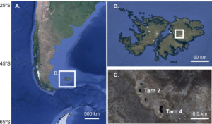
The Falkland Islands at 52oS latitude are within the modern belt of the westerlies and thus any changes in the position of the wind belt should manifest in the Falkland Islands as changes in precipitation, temperature, and wind speed. This work is part of a longer-term study to determine past climate changes in the region. This field season was focused on sampling the lakes of Mt. Usborne, East Falkland to obtain plant collections and surface sediment cores for a modern plant wax isotope calibration study. This calibration will form the basis for my downcore climate interpretations.
Project Goals:
As part of my long-term goal to reconstruct the climate of the Falkland Islands since the last glacial period, my objectives for this research were to collect samples necessary to produce a modern plant-wax isotope calibration for tarns on Mt. Usborne. This calibration will be used in the future on older sediments to reconstruct hydrologic changes in the Falkland Islands.
Initial Results:
We collected five sediment cores using a unicorer device, which captures the sediment-water interface. Three cores were extracted from the high-elevation lakes Tarn 2 and Tarn 4, while the other two were taken from a lower-elevation lake known as Black Tarn. We also collected samples of all prominent plant species in the watersheds adjacent to each of these tarns, as well as modern precipitation and lake-water samples. In the laboratory, we extracted plant waxes from both bulk surface sediments and the individual plant species.
We measured hydrogen isotopes on these samples, as well as on the collected water. Using additional precipitation isotopic data, we determined that terrestrial plant waxes (n-alkanes C29-C33) are tracking local precipitation isotopic composition, in keeping with studies elsewhere. Aquatic plant waxes (C23-C27) are tracking lake-water composition. These findings have resulted in the first-ever plant-wax calibration for high-elevation watersheds in the Falkland Islands and confirm the usefulness of this proxy for paleoclimate research. This work has led to the publication of a paper, on which I am co-author.