

Ground-Penetrating Radar Collection at Los Morteros, Chao, Peru
Expedition Dates: July 16th, 2024 – July 25th, 2024
Field Team Members: Kelly Hoover (MS student, Ph.D. student, UMaine), Allen Gontz
(Professor, Clarkson University), Emily Blackwood (Ph.D. Candidate, UMaine), Dan Sandweiss
(Professor, UMaine), Alice Kelley (Emerita, UMaine), Cecilia Mauricio (Pontificia Universidad
Católica del Perú)
Funding Support: Dan & Betty Churchill Exploration Fund
Introduction:
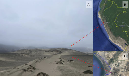
On the Northwest coast of Peru, spilling over a large paleoshoreline sits an early Preceramic
monumental site, Los Morteros, Chao (Figure 1). In July, I traveled to Los Morteros to perform
an updated ground-penetrating radar (GPR) survey to complement the 14 year old GPR data
collected by a UMaine team with some of the original members. GPR surveys of archaeological
sites allow us to image the subsurface of the area, almost like a geological X-Ray, highlighting
the differences in density and reflectivity of the variety of materials below our feet. Through this
method, we are able to distinguish between materials used, or created, by humans for
construction of the monument versus geologically “normal” material. Successful collection,
analysis, and interpretation can be utilized to assist in guiding future excavations at
archaeological sites.
Los Morteros is a Preceramic monumental site with human occupation radiocarbon dated to
~5,800 to 5,200 calibrated years B.P. Archaeological excavation has been carried out at Los
Morteros since 2012 by then-UMaine graduate Ana Cecilia Mauricio. Mauricio used preliminary
GPR data from the UMaine project to guide her excavations in search of evidence for structures
at Los Morteros (Mauricio et al. 2021).
Groundbreaking at the time, today the 2010 GPR data – referred to as “legacy data” – provide
limited help in interpreting site construction, though they remain a key to our analysis of the
geological environment of Los Morteros. For the 14 years since collection, the data have
remained largely untouched while technology caught up with our needs. This summer, we used a
radar on loan from Dr. Mauricio’s institution to collect updated GPR data at Los Morteros and
have identified evidence of man-made structure underneath the surface of the mound. As
analysis advances, this work will contribute to a preliminary understanding of the timeline for
human construction at one of the earliest monumental structures in the Americas.
Methods:
Through part of July 2024, I worked with a team consisting of Dr. Allen Gontz (Clarkson
University), Emily Blackwood, Dr. Alice Kelley, and Dr. Dan Sandweiss (University of Maine)
to collect GPR data on the earliest large-scale monumental site in the region: Los Morteros. Our
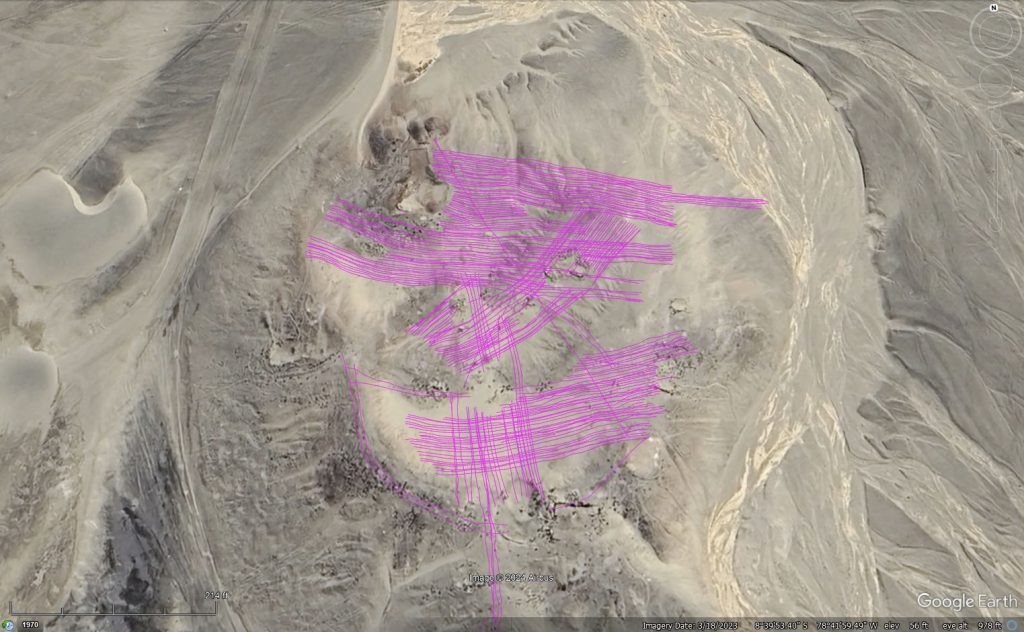
surveys collected nearly 20 km of 600 MHz and 170 MHz GPR data over the mound (Figure 2),
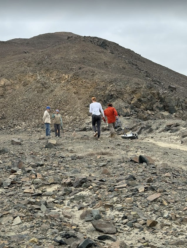
using a dual frequency radar with single wheel attachment, pulled by paracord tied to each
handle. The cord harness allows for better control of the GPR over rocky terrain (Figure 3).
Ph.D. Candidate Emily Blackwood collected over 450 points containing latitude, longitude, and
elevation using the Emlid RTK to contribute to our topographical data package, essential for
future modeling/virtual reconstruction of the site.
Los Morteros is a U-shaped complex that is seemingly terraced in its center. In order to cross any potential structure at its perpendicular (the most effective way to get a clear understanding of true shape and continuity between lines), we split our survey into 4 sections. Sections 1 through 3 contain East-West lines and fall generally along the terraces in descending order from the highest elevation terrace of the site (south), to the lowest elevation terrace (north) (Figure 2). Section 4 contains all North-South lines, which bisect Sections 1 through 3, allowing all sections to be placed in context with one another through these overlapping lines.
Collection of survey lines (Figure 2) was extremely efficient. One individual was responsible for pulling the instrument along the terrain, joined by at least one other individual responsible for the wirelessly connected tablet which includes starting/stopping collection, observing the real time data collection on screen, noting key information (line number, direction, surface environment that might impact collection, and interesting signals) into the field notebook, and assisting the individual pulling the instrument when necessary.
Significance:
Analysis of the data collected during the 2024 field season at Los Morteros is ongoing, but
preliminary interpretations suggest the presence of aeolian sand over anthropogenic structures,
including walls, rooms, and floors. With continued processing and interpretation, identifying
these features in their geological context will provide incredible insight into the development of
monumentality in the Americas and the relationship between growing populations and the
environment. Additionally, the collation of this year’s GPR data with the 14 year old “legacy”
data proves to be an intriguing analog for the continuity of technology within the archaeological
field.
Acknowledgements:
Thank you to Dan and Betty Churchill for funding this research. Without the Churchill
Exploration Fund it would not have been possible to do the work. Thank you to Allen Gontz,
Alice Kelley, Dan Sandweiss, and Emily Blackwood, all of whom were invaluable to the
interdisciplinary approach this work requires. And thank you to Ana Cecilia Mauricio, for
loaning us the GPR and for facilitating access to the site; her research on Los Morteros during
her time at UMaine over a decade ago has been as important to this research as her continued
involvement in work at the site today: immeasurable.
References:
Mauricio, A. C., Grieseler, R., Heller, A. R., Kelley, A. R., Rumiche, F., Sandweiss, D. H., &
Viveen, W. (2021). The earliest adobe monumental architecture in the Americas.
Proceedings of the National Academy of Sciences, 118(48), e2102941118.