Ground Penetrating Radar of Investigation of Coastal Environments: The Republic of Ireland
Ground Penetrating Radar of Investigation of Coastal Environments: the Republic of Ireland
Field Team Members: Lee Sorrell & Joseph Kelley
June 11-22, 2013 Field Season
Funding Support: Dan and Betty Churchill Exploration Fund
This research is aimed at further understanding beach and coastal systems in relation to sea-? level change in the Republic Ireland. Our goal was to use ground-?penetrating radar (GPR) to investigate the subsurface of three separate coastal environments. Funding by Dan and Betty Churchill provided travel expenses for Lee Sorrell, School of Earth and Climate Sciences graduate student.
June 11–22, 2013 Field Season
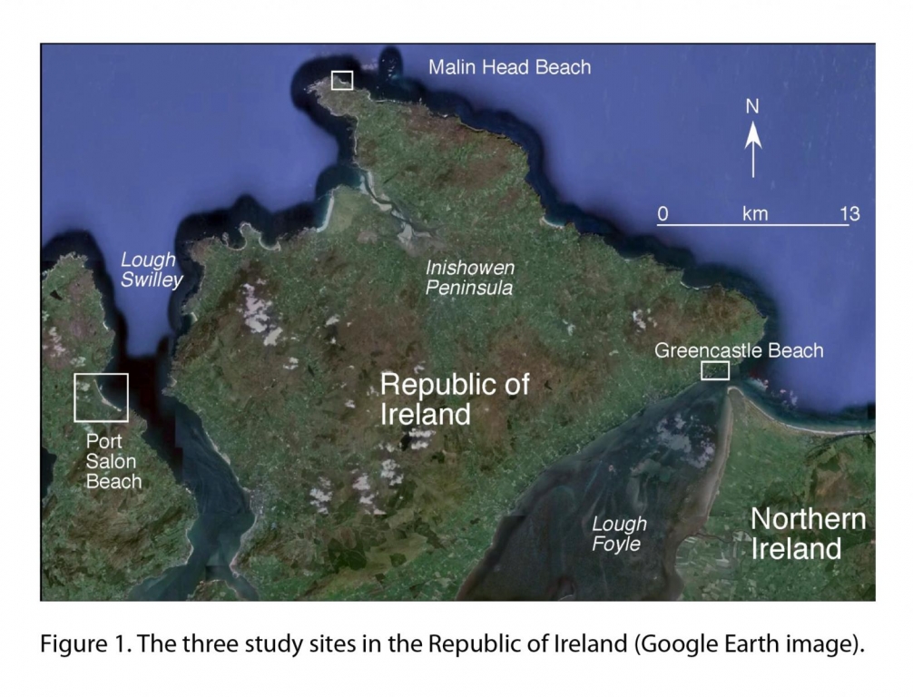
This study was conducted as a joint project between the University of Maine, represented by Dr. Joseph Kelley and Lee Sorrell (Climate Change Institute) and The University of Ulster in Coleraine, represented by Dr. Andrew Cooper. Dr. Andrew Cooper, Professor of Coastal Studies, provided GPR equipment (Sensors and Software Pulse Ekko 1000), logistical support, and field expertise. Three field locations (Figure 1) were investigated during the 10 day field expedition: a raised (higher than present sea level) cobble/sand beach in Greencastle, Donegal, a raised gravel beach in Malin Head, Donegal and a freshwater marsh at Port Salon Beach on the west side of Lough Swilly, Donegal. At each site, GPR profiles were collected in a grid across the field site to provide a three dimensional image of the subsurface. Additionally, a GPS was attached to the GPR during data collection to record profile locations and the topography along each profile. Due to exposed electrical connections, GPR data collection is limited to relatively dry conditions. This region’s notoriously wet weather meant several “weather days” when GPR data collection was prohibited by rain. This time was used for field reconnaissance.
GreenCastle
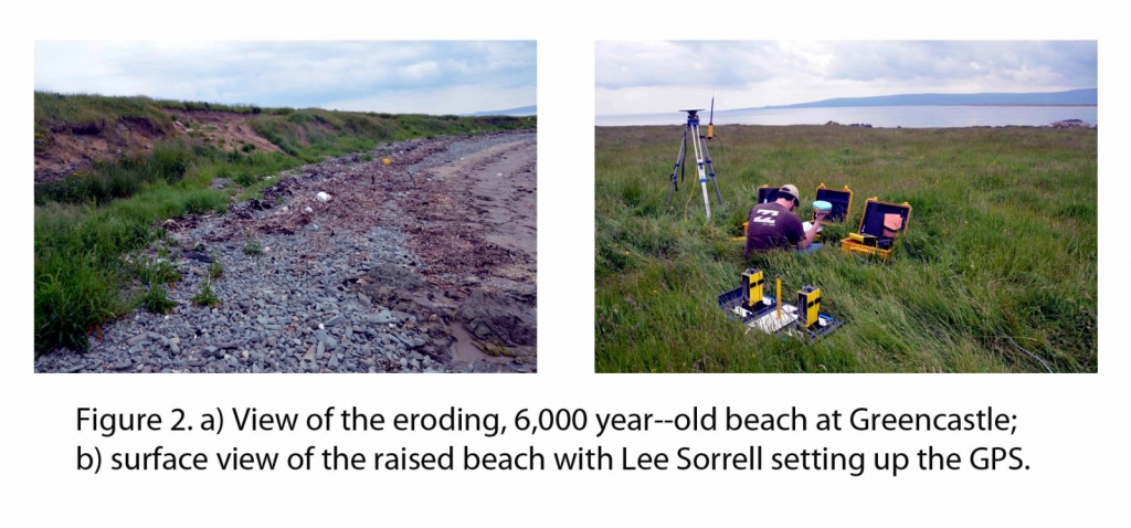
The beach at Greencastle is located on the north coast of the Republic of Ireland, on the west shore of Lough Foyle (Figure 1). This beach is composed of cobbles and sand, provided by the erosion of stratified layers of sand and cobbles exposed in an erosional scarp (Figure 2a). The sand and gravel outcrop marks a raised (higher-?than-?present sea level) beach. Seaward of this raised beach is a submerged Mesolithic archaeological site that is undergoing excavation by divers. Our interest was focused on the stratigraphy and overall geometry of the raised beach, which itself hosts an apparent Neolithic stone circle.
Twenty four GPR profiles were collected in a grid (Figure 2b), with profiles oriented both normal and parallel to the shore. The good exposure along the eroding beach provided excellent ground truth for the GPR. Work is on-?going on the geophysical records, but we established the overall sequence of events through GPR and field observations.
During the Mesolithic, the site is interpreted to have been located near sea level, and occupied by people who left behind the remains of flint tool production. The site was later covered by a wetland as sea level in the area fell, and then was subsequently drowned ca. 6,000 years ago when sea level rose several meters above the present level. The sea eroded glacial deposits to produce a gravel beach that covered the older materials. Preliminary work suggests that the raised beach is far more extensive than first thought and itself developed as a spit and tombolo at various times during its growth.
Malin Head
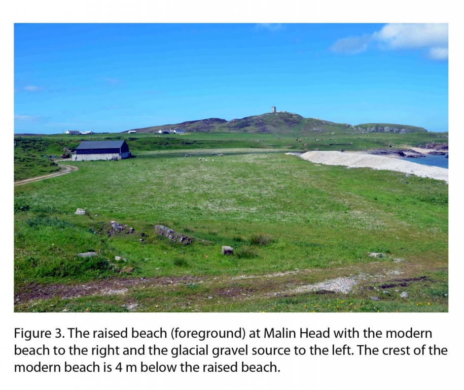
Our study site in this area (Figure 3) was focused on a cobble beach east of Malin Head, the northernmost point of Ireland (Figure 1). The purpose of the GPR efforts at this location was to investigate the 3-?dimensional geometry of the raised gravel beach and to interpret the geology of its source materials. The modern beach is composed of large, rounded cobbles, and has an extremely steep profile with a high gravel ridge behind the shoreface. Profiles were collected in a grid with lines both normal and parallel to the shore. Profiles were collected both on and behind the gravel beach; additional profiles were collected in the fields farther landward from the beach further characterize the glacial-?age source materials. Twenty GPR profiles were collected at this site.
On the basis of the GPR records and several stream-?eroded exposures, we interpret the source of material for the raised beach (also presumably ca. 6,000 years old) as an ice-?proximal, subaqueous fan. This is in contradiction to an earlier interpretation that identified the source as a late glacial (19,000 years ago) highstand beach. The abundance of mud in the late glacial fan deposit precludes this interpretation, and implies that the raised beach derived its cobbles by wave-?winnowing mud from the glacial material. Modern sea-?level rise is eroding the raised beach to source the contemporary, wave-? exposed beach. The thickness of the raised beach (>5 m) suggests that on-?going beach erosion has a large supply of material to maintain the beach for a long time.
Lough Swilly
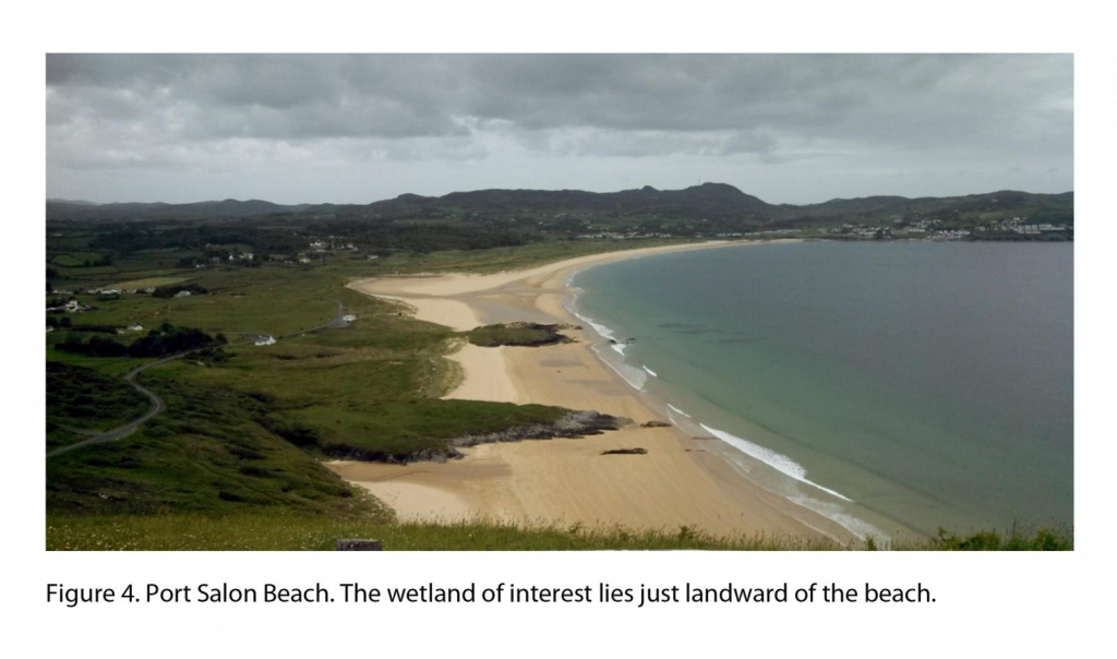
Lough Swilly is located in the Republic of Ireland between the Inishowen Peninsula and the Fanad Peninsula (Figure 1). Our study area, Port Salon Beach and its back-?barrier wetland (Figure 4), is located on the western portion of the Lough. A drained, freshwater marsh currently used for grazing sheep is located behind the beach., This freshwater deposit is underlain by material deposited in salt marshes during the mid-?Holocene sea level highstand (ca. 6,000 years ago) in this region. Work at this location provided a unique opportunity to image salt marsh stratigraphy using GPR. Because the electromagnetic waves produced by GPR are attenuated by salt, no GPR profiles have been collected in salt marshes.
Lough Swilly is located in the Republic of Ireland between the Inishowen Peninsula and the Fanad Peninsula (Figure 1). Our study area, Port Salon Beach and its back-?barrier wetland (Figure 4), is located on the western portion of the Lough. A drained, freshwater marsh currently used for grazing sheep is located behind the beach., This freshwater deposit is underlain by material deposited in salt marshes during the mid-?Holocene sea level highstand (ca. 6,000 years ago) in this region. Work at this location provided a unique opportunity to image salt marsh stratigraphy using GPR. Because the electromagnetic waves produced by GPR are attenuated by salt, no GPR profiles have been collected in salt marshes.
Conclusions
The generous grant from the Churchill Fund provided travel expenses related to work in the Republic of Ireland and Northern Ireland. In the course of a ten-?day field season, completed our investigations of three different locations. We collected over 4.5 km of GPR profiles that will be used to provide geological context for archaeological material and investigate the stratigraphy of a mid-? Holocene highstand shoreline.