
Glacier History of New Zealand Southern Alps from LGM to present
Glacier History of New Zealand Southern Alps from LGM to present
Field Team Members: George H. Denton, Aaron E. Putnam, Tobias N.B. Koffman (Ph.D. candidate), Peter D. Strand (M.S. candidate)
Collaborators: Dr. Joerg M. Schaefer (Columbia University), Dr. Michael R. Kaplan (Columbia University), David J.A. Barrell (GNS Science), Dr. Brian M. Anderson (Victoria University of Wellington), Dr. Sean D. Birkel (University of Maine), Roseanne Schwartz (Columbia University), Dr. Robert Finkel (Lawrence-Livermore National Laboratory)
New Zealand Southern Alps. January 11, 2013 – March 3, 2013
Funding support: National Science Foundation, Comer Science and Education Foundation, and the Quesada Family Foundation
Late Pleistocene ice ages represent the largest changes in Earth’s climate over the past one million years. Uncovering the causes of ice age inceptions and their subsequent terminations remains a major mystery in paleoclimate. In addition, understanding the reorganizations of Earth’s atmospheric and oceanic circulations is the key to understanding how Earth’s climate system operates over millennial scales. We are interested in climate fluctuations during the Last Glacial Maximum (~26,000 – 16,000 years before present) and also during the Holocene (~11,000 years ago to present). In particular, we aim to determine both the chronology and the signature of rapid transitions from glacial to interglacial conditions, known as “glacial terminations”. Were glacial terminations in the Northern and Southern Hemispheres synchronous, or did the signatures differ? In order to decipher these important paleoclimate problems we travelled to mountain glaciers in the Mackenzie Basin of the South Island of New Zealand.
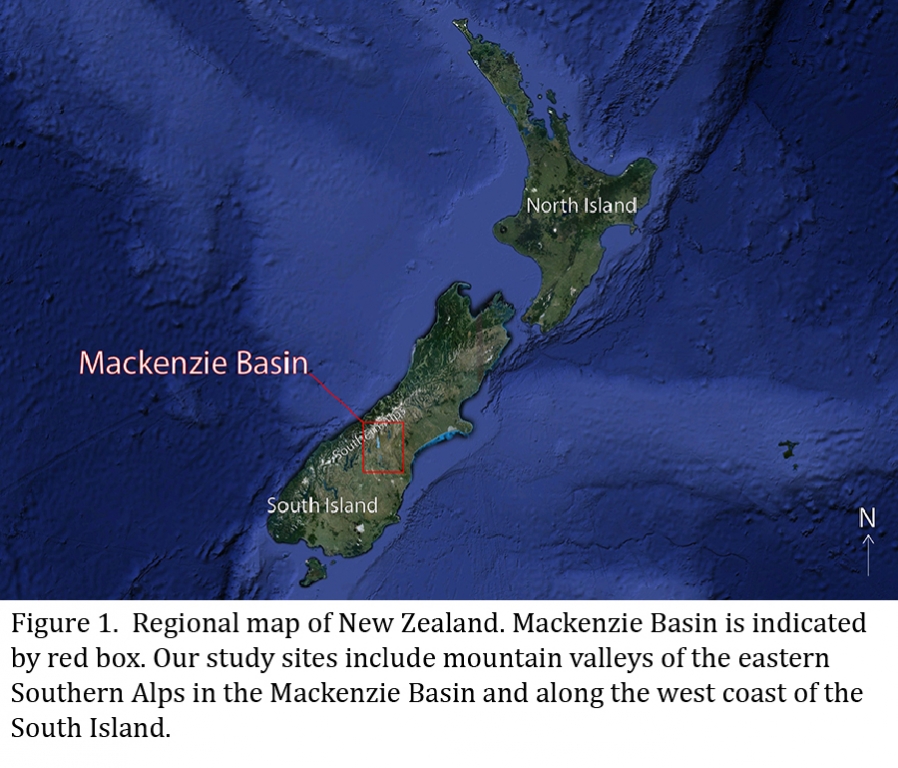
New Zealand is an ideal location for developing a southern hemisphere glacial chronology. New Zealand is antipodal to the North Atlantic region, and thus on the opposite side of the planet from extensive Northern Hemisphere glaciers in both North America and Europe. The South Island extends from 40-46°S, 164-170°E, placing it on the fringe of the Southern Ocean, just north of the modern subtropical front, and squarely in the Southern Hemisphere westerly wind belt. The modern mean-annual snowline currently intersects the Southern Alps, the mountain range extending down the spine of the South Island. The Mackenzie Basin is located at ~44°S latitude, in the eastern rain shadow of the Southern Alps. The complete glacial record of both the Holocene and Late Pleistocene is well preserved on the landscape.
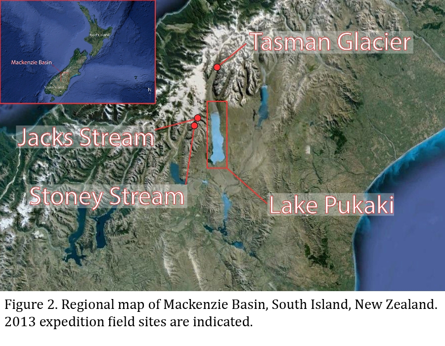
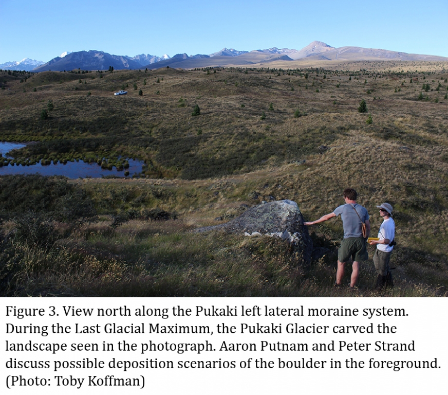
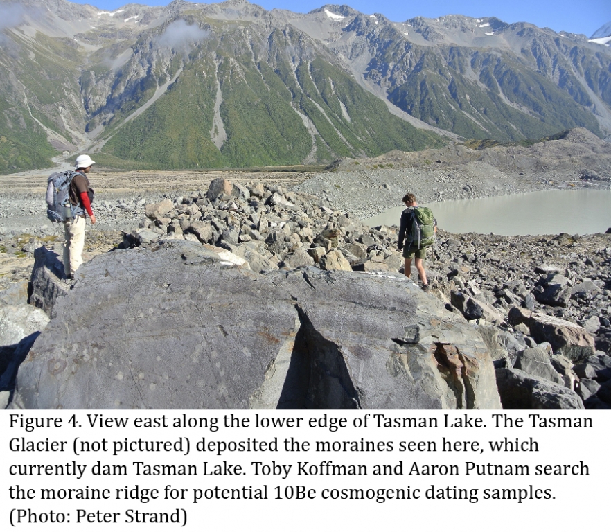
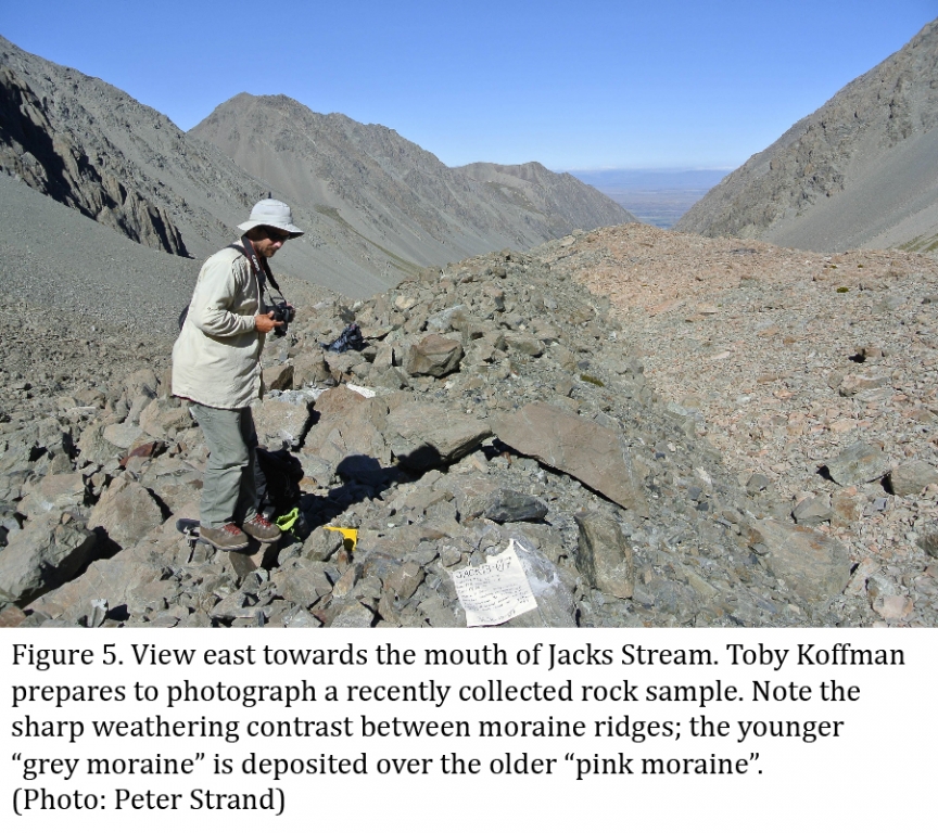
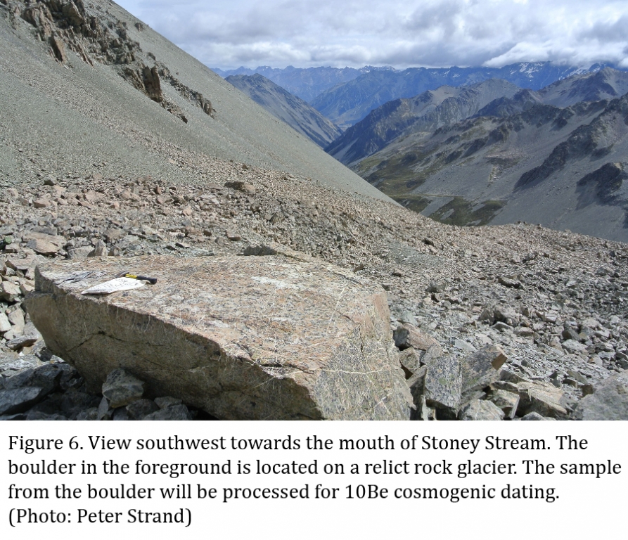
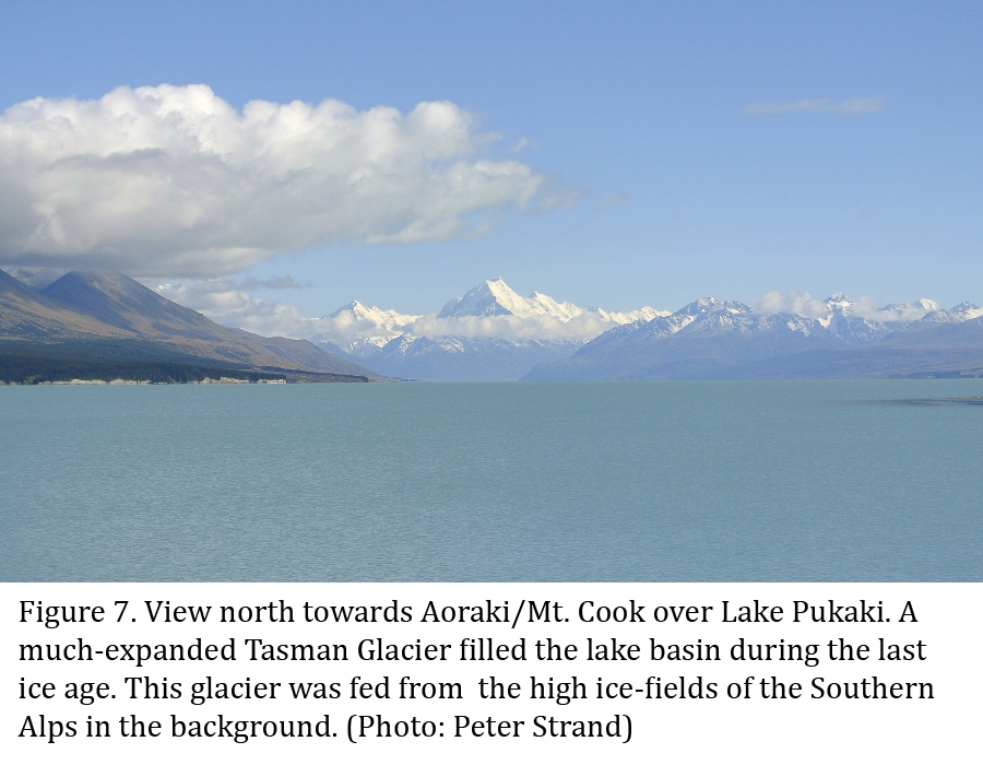
During our most recent field season, we focused our sampling efforts on glacial deposits from glaciers draining the high elevation ice-fields around Aoraki/Mt. Cook and along the Ben Ohau Range in the Southern Alps. During the Last Glacial Maximum, these glaciers coalesced to form large piedmont lobes that shaped a variety of glacial landforms seen today. Debris deposited at the margins of the glacier formed large ridges on the landscape, known as moraines. The moraine ridges represent the spatial extent of the glacier, when atmospheric temperatures were much colder than present day. During the most recent field season, we concentrated on lateral moraines, east of Lake Pukaki, that were deposited during both the Last Glacial Maximum and prior events. Farther up valley, we sampled moraines deposited by smaller glacier advances during the early part of the Holocene. In the Ben Ohau Range, we visited two high-elevation valleys of differing aspects, Jacks Stream and Stony Stream, in order to compare multiple Holocene signals from the Southern Alps. We sampled moraine ridges and relict rock glaciers.
We use careful geomorphic mapping to reconstruct the geometries of former glaciers. The culmination of several years of effort in this regard was published as a GNS Science monograph in 2011 (Glacial Geomorphology of the Central Southern Island, New Zealandby David J.A. Barrell, Bjorn G. Andersen, and George H. Denton) and can be viewed online at http://maps.gns.cri.nz/website/csigg/. Mountain glaciers in the Southern Alps respond to changes in atmospheric temperature in generally a straightforward fashion. Therefore, snowline constructions or glacial modeling simulations that incorporate glacial geomorphological extents can quantify past temperature changes. In addition to glacial geomorphologic field mapping, we work closely with the Lamont-Doherty Earth Observatory Cosmogenic Nuclide Laboratory to develop chronologies of the landforms. The 10Be surface-exposure dating technique involves collecting field samples from the top surfaces of boulders situated on moraine crests. At LDEO, we extract beryllium from quartz in the rock samples using a suite of geochemical techniques. The ratio of 10Be/9Be is then measured at the Lawrence-Livermore National Laboratory Center for Accelerator Mass Spectrometry. Recent advances in 10Be dating techniques have lead to precision that rivals even radiocarbon dating. Recent work (Putnam et al., 2010) has greatly increased the accuracy of the dates by determining the local 10Be production rate. These advances allow us to determine the exact dates of landform construction, ranging from millions of years before present, to those of historical times. Using glacial geomorphological and glacial chronological techniques together, we are able to create a detailed and accurate temperature history of the South Island of New Zealand. This record can then be compared to other proxy records from the Northern Hemisphere and Antarctica, in order to determine the drivers of global climate changes and further our understanding of ice ages.
Relevant Publications:
Denton, G.H., Anderson, R.F., Toggweiler, J.R., Edwards, R.L., Schaefer, J.M., Putnam, A.E., 2010. The last glacial termination. Science, 328, 1652–1656,
Schaefer, J. M., Denton, G. H., Kaplan, M., Putnam, A., Finkel, R. C., Barrell, D. J. A., et al. (2009). High-Frequency Holocene Glacier Fluctuations in New Zealand Differ from the Northern Signature. Science, 324(5927), 622–625.
Putnam, A.E., Schaefer, J.M., Denton, G.H., Barrell, D.J.A., Birkel, S.D., Andersen, B.G., Kaplan, M.R., Finkel, R.C., Schwartz, R., Doughty, A.M., 2013. The Last Glacial Maximum at 44S documented by a 10Be moraine chronology at Lake Ohau, Southern Alps of New Zealand. Quaternary Science Reviews Elsevier Ltd 62, 114–141.
Schaefer, J.M., Denton, G.H., Barrell, D.J., Ivy Ochs, S., Kubik, P.W., Andersen, B.G., Phillips, F.M., Lowell, T.V., Schlüchter, C., 2006. Near-synchronous interhemispheric termination of the last glacial maximum in mid-latitudes. Science American Association for the Advancement of Science 312, 1510–1513, doi:10.1126/science.1122872.
Putnam, A.E., Schaefer, J.M., Barrell, D.J.A., Vandergoes, M., Denton, G.H., Kaplan, M.R., Finkel, R.C., Schwartz, R., Goehring, B.M., Kelley, S.E., 2010. In situ cosmogenic 10Be production-rate calibration from the Southern Alps, New Zealand. Quaternary Geochronology Elsevier B.V 5, 392–409.
Barrell, D.J.A., Andersen, B.G., Denton, G.H., 2011. Glacial Geomorphology of the Central South Island, New Zealand. GNS Science.