Abrupt Climate Change during the Last Glacial Termination in Maine
Expedition Team Members:
Maraina Miles¹ ²
¹Climate Change Institute, University of Maine
²School of Earth and Climate Science, University of Maine
Expedition Dates: May-October 2022
Funding Support: The Robert & Judith Sturgis Family Foundation
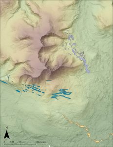
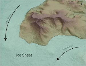
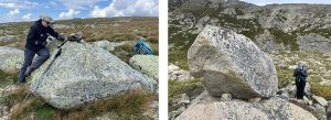
Methods: To find out when the ice retreated or readvanced, we began by mapping glacial landforms in ArcGIS Pro using newly released LiDAR imagery of the area. Next, we collected rock samples from boulders on these landforms. The samples were brought back to the UMaine Cosmogenic Isotope Laboratory and are currently being processed for beryllium-10 (10Be) surface exposure dating. This method works like an isotopic ‘clock’ and reveals when the boulders were deposited by a glacier. The boulders were plucked from the underlying bedrock by a flowing glacier and then deposited on a moraine. Once a boulder is released from the glacier and exposed to the atmosphere, it begins accumulating 10Be, a cosmogenic isotope that forms within a rock as is it bombarded with cosmic rays, which are constantly raining down on Earth. Therefore, the amount of 10Be in a boulder can tell us when that boulder was deposited by a glacier, and thus when the glacier was last at that location. To isolate the 10Be, the samples are crushed into a fine sand and etched in acid until only pure quartz remains. The quartz is then dissolved, and the 10Be is extracted in a series of chemical steps.
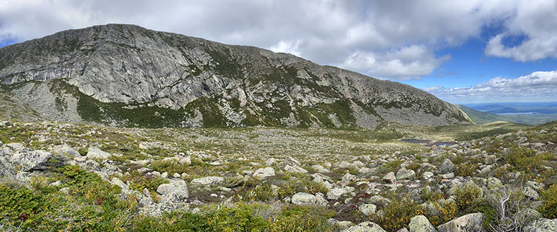
Project Goals & Initial Results: One of our goals during the summer of 2022 was to collect samples along a newly discovered lower-elevation moraine in the southern section of Baxter State Park, dubbed the
‘Togue Pond moraine.’ This moraine may have been deposited in the Bølling–Allerød (14.7-13.0 ka), a period when the climate changed rapidly but displayed many complexities that we don’t yet understand. Because of the steep slope of the moraine, this may be evidence of a glacial readvance during the Bølling–Allerød. Overall, 10 samples were collected on the moraine. We also collected six samples above the moraine, on smaller recessional ridges, and eight below it to fully constrain the timing of moraine deposition. Along with the lower-elevation work, we collected samples at higher elevations on the tableands to determine if ice was present during the last glacial maximum. We also explored North Basin to assess if cirque glaciers were present during the termination. Many of these samples have been processed (fig.1), however many more are currently in progress and await analysis at Lawrence Livermore National Laboratory in California.