
Characterizing the Effects of Elevation and Ice Deformation on the Begguya (Mt. Hunter) Ice Core Record
Expedition Field Team Members:
Emma Erwin 1,2,3 Ingalise Kindstedt1, Liam Kirkpatrick4,5, Scott Braddock1,2
1University of Maine, Climate Change Institute
2University of Maine, School of Earth and Climate Sciences
3Cold Regions Research and Engineering Laboratory
4Dartmouth College, Department of Earth Science
5University of Washington, Department of Earth and Space Science
Expedition Funding: The Robert and Judy Sturgis Family Foundation, American Alpine Club, University of Maine Graduate Student Government, and Maine Space Grant Consortium.
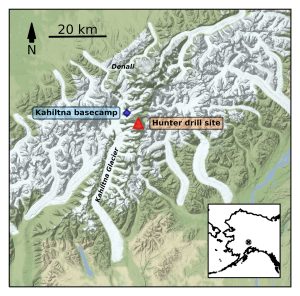
Field Expedition Location: Denali National Park, Alaska
Expedition Dates: May 27 – June 27, 2022
Background and Significance:
As global atmospheric temperatures continue to rise, glaciated high-mountain regions are of special concern because of their potential near-term contribution to global sea level rise (Meier et al. 2007; Hugonnet et al. 2021), importance as water resources (Barnett, Adam, and Lettenmaier 2005), and their higher rates of warming than lower elevations (e.g. Williamson et al. 2020). In particular, melt from Alaskan alpine glaciers has contributed over 25% of observed sea level rise to date and these glaciers continue to lose ice mass at some of the highest rates globally (Zemp et al., 2019; Hugonnet et al., 2021).
Paleoclimate records from Alaska provide important context for predicting the response of glaciers in the region to projected warming in the coming centuries. Two surface-to-bedrock ice cores were drilled on the Begguya summit plateau in 2013, referred to as the “Denali ice cores”. Analysis of the upper portion of the 2013 cores has produced a high-resolution record of Alaskan paleoclimate dating back 1,200 years. The cores reveal a sixtyfold increase in total annual melt at the site since ~1850, indicating summertime warming over the past 170 years, and a doubling of snow accumulation over the same period (Winski et al. 2017; Winski et al. 2018). The cores provide one of the few available long term records of Alaskan precipitation and hydroclimate. Analysis of the lower portion of the 2013 cores will likely extend this record back >10,000 years, resulting in a virtually complete Holocene paleoclimate record. However, several unanswered questions present challenges to completing analysis and interpretation of the 2013 Denali cores.
Field Research Summary:
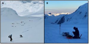
This summer 2022 field season was split into two phases: (1) Kahiltna glacier snow and firn survey and (2) Begguya summit plateau radar surveys and firn cores. Phase 1 involved climbing from base camp (2,200 m a.s.l.) to camp 2 (3,414 m a.s.l.) on the West Buttress route of Denali. We spent four days ascending and acclimatizing, during which we collected snow surface samples to be used for isotope step analysis. During the three day descent, we collected a 13.6 km transect of 400 MHz ground-penetrating radar (GPR) data which will be used to compare firn thickness changes with a similar transect collected in 2012 (Campbell et al.,2012). This radar transect doubled as our team’s acclimation time at high elevation before traveling to the Begguya field site (~13,000 ft) and allowed our bodies to adapt up to 11,000 ft without any incidence of altitude illness.
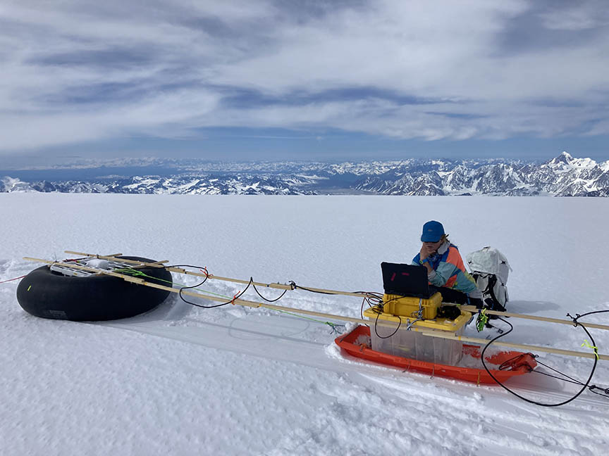
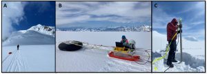
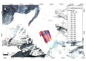
During the second phase of our expedition, we spent approximately three weeks on the Begguya summit plateau. There, we executed numerous radar and GPS surveys and extracted two 18 m firn cores. For radar surveys, we used GPR and Autonomous Phase-sensitive Radio-Echo Sounder (ApRES) systems to measure ice depth and vertical velocity across the plateau. We collected 22 point measurements with the ApRES at 50 m spacing along the cross-sections of an approximately 600 m2 grid (Figure 4). These measurements were repeated after 14 days to evaluate change in depth of reflected internal layers within the ice pack (Figure 5). Additionally, hourly measurements were collected during the intervening 14-day period at the site of the 2013 surface-to-bedrock ice cores. GPR surveys included a swath of transects at 50 m spacing across the plateau in North-South orientation (Figure 4) using 10 MHz, 400 MHz, and 900 MHz antennas. This range of antenna frequencies allowed for high resolution imaging of near-subsurface features within the ice down to bed topography. A GPS survey was conducted to measure surface velocity across the plateau by measuring the movement of 50 velocity stakes over a week-long period at centimeter-level precision using an Emlid Reach2 in RTK mode. Finally, we extracted two 18 m firn cores from the plateau. The first core was extracted in meter-long segments and remained frozen and transported to Dartmouth for processing. The secondary core was sampled in the field for water isotopes as a backup for the first core. We were fortunate to have weather conditions that allowed for data collection of all our planned objectives.
Initial Results:
Results from the 10 MHz GPR survey provide bed depth measurements across the survey area and ranged from 120-270 m. This survey revealed a trough beneath the location of the centerpoint. Preliminary processing of ApRES data shows quantifiable vertical deformation over the 14-day interval at all 22 points measured across the plateau. Vertical strain rates were calculated from the gradient of each vertical velocity profile. However, resolvable data is limited to depths between 20-150 m due to spectral leakage from the strong bed reflection and sidewall reflections from undulating topography. All other radar data (Kahitna GPR survey, remaining Begguya GPR surveys) will be processed within the next six months. All surface snow samples and firn cores have been transported safely to Dartmouth, where they will be processed for isotope and aerosol signatures. The core collected this season will extend the climate record from the 2013 surface-to-bed ice cores to present.
Conclusion:
Our team completed all proposed research objectives during our season. In addition, we successfully deployed an ApRES system in an Alaskan alpine environment for the first time and demonstrated the applicability of the system and its use at similar sites across the region. Preliminary results of the Begguya geophysics survey were presented at the International Partnerships in Ice Core Sciences (IPICS) conference in Crans-Montana, Switzerland in October 2022. Further results will be shared at the American Geophysical Union conference in December 2022. We were fortunate to have good weather conditions and camaraderie throughout our month in the Alaska Range. Fieldwork was conducted on the native lands of the Dena’ina peoples under Denali National Park permit #DENA-2022-SCI-008 and would not have been possible without the support of Denali National Park Rangers and Talkeetna Air Taxi. Additional funding for this project was provided by the American Alpine Club, University of Maine Graduate Student Government, and Maine Space Grants.
Funding Acknowledgement: Funding for this project was generously awarded by the Bob and Judy Sturgis Exploration Fund as well as the American Alpine Club, University of Maine Graduate Student Government, and Maine Space Grant Consortium. We are grateful for this funding, without which this project would not have been possible. Fieldwork was conducted on the native lands of the Dena’ina peoples under Denali National Park permit # DENA-2022-SCI-008. The success of the field campaign was made possible by the support of Denali National Park Rangers and Talkeetna Air Taxi. We thank the Climate Change Institute and Dr. Paul Mayewski and Dr. Daniel Dixon for the use of the ice drill and Dr. Karl Kreutz and Dr. Seth Campbell for their valuable input into our science objectives.