Old Glaciers and New Methods: Applied Ground Truthing Methods for Ground Penetrating Radar on the Seward Glacier

Expedition Dates:  May 2022

Expedition Field Team Members:

Jonathan Maurer (M.Sc. Student)1, 2

Dr. Seth Campbell1, 2

Dr. Kristin Schild1, 2

Dr. Yifeng Zhu3


1) University of Maine – School of Earth and Climate Sciences

2) Climate Change Institute, University of Maine

3) University of Maine – Electrical and Computer Engineering


Expedition Funding: The Robert & Judith Sturgis Family Foundation and the University of Maine Graduate Student Government.

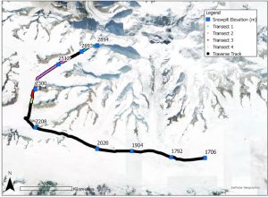
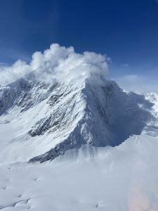
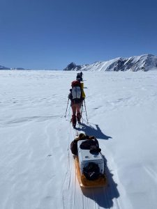
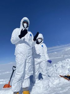
Field Expedition Location: Seward Glacier, Alaska
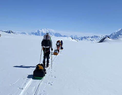
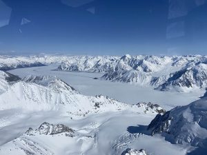
 

Significance:

High elevation mountain glaciers are referred to as the “water towers of the world” due to their ability to store water internally and release it later through melt and runoff. In addition to storage, the height of these mountains allows this released water to flow over incredible distances, supplying distant populations with precious resources that otherwise would not exist. To protect these critical water resources, we must be able to assess and predict the impacts of climate change with a high degree of accuracy. This study approached this issue by attempting to refine assumptions in the spatial and temporal variability of radio wave velocities during a traverse of the Bering Glacier in May of 2022. This traverse was a total length of 65 km, and encompassed elevations between 1705-2894 meters. During this, 9 pits were sampled for various chemical and physical characteristics and meteorological conditions were recorded (figure 1). At each of these pits, a ground truthing method was applied to pinpoint the exact depth of a radio wave at a known time, allowing for the use of simple algebraic equations to solve for the relative permittivity of the snowpack (figure 2). By refining this assumption in a controlled setting, we attempt to elucidate underlying factors that impact a key source of uncertainty in when using ground-penetrating radar in temperate glacial environments.


Map with snow pit locations.
Figure 1. A map of the transect performed on the Seward Glacier. Blue squares indicate snow pits, with associated elevations measured in meters


Diagram of ground truthing methods.
Figure 2. A diagram of ground truthing methods used in this study. Plot 2a provides a cross sectional view of the method, showing the probe inserted at the bottom of the pit perpendicular to the direction of digging. Plot 2b provides a side view of the method, showing the movement of the GPR over the inserted probe to get the exact depth of the radio wave at a given time.


Field Photos:


Accomplishments:

The initial objective of this study was to collect expansive ground-penetrating radar (GPR) data along a traverse of the Seward Glacier to expand the training dataset of a deep learning algorithm. Due to malfunctions in the battery charging equipment used for this study, a more focused approach was chosen. Rather than a full transect of the region, ground truthing of radio wave velocities at the predetermined snow pit sites was prioritized. This approach made use of the limited battery life available while still collecting useful information. Objectives for this study included:

Objective 1: Refine the impact of spatial variability on radio wave velocities with respect to changes in elevation and associated changes in snowpack and atmospheric conditions on a daily timescale.

Objective 2: Refine the impact of temporal variability on radio wave velocities with respect to changes in the snow column due to diurnal cycles of heating and insolation and the associated migration of liquid water through the snowpack.

The updated goal of this study was to explore how heterogeneities forced by the relationship between complex topographical and meteorological patterns impact radio waves moving through a medium. These objectives were designed to take a two pronged approach to answering this question. The first aimed to address low frequency variability over a vast region, while the second aimed to address localized high frequency variability at a fixed point. These updated objectives allowed for the most efficient use of resources despite limitations.


Future Work:

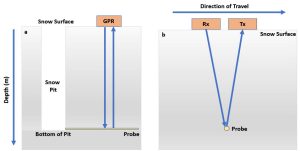
While not the original intention of this proposal, this project serves as a framework for future ground truthing of GPR measurements in glacial environments by testing an assumption critical to the interpretation of data. As a first attempt, the results of this work will inform further studies of similar scope, with the hopes of eventually developing a standardized methodology for local corrections of radar wave velocities. Once developed and applied, generalized corrections can be made by interpolating between ground truth sites. This will improve the understanding of englacial stratigraphy, and strengthen claims made from the results of future studies.


Funding Acknowledgement:

Funding for this project was provided by the Sturgis Fund and the University of Maine Graduate Student Government. These combined funding sources totaled $1,976.96. Funding from The Sturgis Field Fund primarily funded the travel to Yukon, CA and to Juneau, AK. These funds also provided the ability to purchase global rescue insurance, a necessary service for remote back country work. Funding from the Graduate Student government primarily helped offset additional travel costs and baggage fees due to the large size of the mountaineering and scientific equipment needed for this trip. Without these funding sources, this expedition would not have been possible.