
Climate Impacts on Glaciers of the Southern Patagonian Icefield, Chile
Expedition Dates – September 22nd-October 8th, 2019
Field Team: Scott Braddock1,2, Kristin Schild1,2, Raul Pereda3, Felidor Paredes3, Fernando Iglesias Letelier4
1 – University of Maine – Climate Change Institute
2 – University of Maine – School of Earth and Climate Sciences
3 – CONAF –Department of Protected Areas
4 – Round River Conservation Studies – Patagonia Program
Expedition Funding – Churchill Exploration Fund, American Alpine Club and Geological Society of America
Summary:
Like most glaciers around the world, the Southern Patagonian Icefield (SPI) is retreating in the face of rising atmospheric and ocean temperatures. Furthermore, the SPI is particularly susceptible to a changing climate because of its relative proximity to the equator and that it is made up of low-elevation alpine and tidewater glaciers that are highly sensitive to changes in temperature and precipitation. Past studies have shown that ice mass loss from the SPI contributes a large amount of water to global sea level rise, especially relative to the size of the icefield, with rates increasing in recent decades. However, how quickly the SPI is continuing to respond to warmer conditions and the primary mechanisms behind ice mass loss remain important questions to be answered. The glaciers of the SPI are located in Chile’s largest protected area, Bernard O’Higgins National Park (BONP) which hosts the largest known population of the endangered huemul deer – a species whose health is connected with recently-deglaciated habitat. Under the supervision of Coporacion Nacional Forestral (CONAF), limited in situ research exists in the BONP due to the frequent inclement weather, poor access and only a handful of CONAF park guards and scientists to protect and manage a large area. Given the results of studies highlighting the accelerated retreat of the SIF in the past several decades, further work is necessary to better constrain estimates of ice loss and glacier stability as well as impacts on biodiversity in BONP.
Resumen:
Tal como la mayoría de la criósfera en el mundo, en el Campo de Hielo Sur (CHS) los glaciares están retrocediendo ante el aumento de las temperaturas atmosféricas y oceánicas. Además, el CHS es particularmente susceptible a un clima cambiante debido a su relativa proximidad al ecuador y a que está formado por glaciares alpinos y de marea de baja elevación que son altamente sensibles a los cambios de temperatura y precipitaciones. Estudios anteriores han demostrado que la pérdida de masa de hielo del CHS contribuye con una gran cantidad de agua al aumento global del nivel del mar, especialmente en relación con el tamaño de este campo de hielo, con tasas que aumentan en las últimas décadas. Sin embargo, qué tan rápido el CHS está respondiendo a condiciones más cálidas y a los mecanismos principales detrás de la pérdida de masa de hielo continúan siendo preguntas importantes que deben ser respondidas. Los glaciares del CHS se encuentran en el área protegida más grande de Chile, el Parque Nacional Bernardo O’Higgins (PNBO), que alberga la población más grande conocida del ciervo huemul (Hippocamelus bisulcus), el que se encuentra en peligro de extinción, una especie cuya salud está relacionada con el hábitat recientemente deglaciado. La conservación de esta especie está bajo la supervisión de Coporacion Nacional Forestral (CONAF), y pese a que existe una investigación in situ en el PNBO, ésta se ve limitada debido a la frecuencia de un clima inclemente, la inaccesibilidad y que solo se cuenta con un puñado de guardaparques y científicos de CONAF para proteger y administrar un área tan grande. Dados los resultados de los estudios que han demostrado el retroceso acelerado del CHS en las últimas décadas, se necesita más trabajos científicos para afinar mejor las estimaciones de pérdida de hielo y la estabilidad de los glaciares, así como los impactos sobre la biodiversidad en PNBO.

Project Goals:
The primary goals of this project are to identify the dominant mechanism of tide-water glacier acceleration in the SPI, specifically Témpano and Bernardo Fjords (Figure 1), and to establish a working relationship with both local Chilean government (CONAF) and international (Round River Conservation Studies) organizations to continue this research theme into the future. This partnership will provide resources and logistical support as well as the opportunity to share equipment and data in the greater effort of understanding and conserving the SPI. In addition, we will have the opportunity to not only publish our findings in journals but also to share these findings with local communities and students (ages 8-21) through field trips, classroom visits and citizen-science efforts around the SPI. It is our hope that this interdisciplinary approach will help to inform and involve these communities to continue conservation and protection of national parks in Chile and build upon our research efforts in a collaborative nature.
Scientific significance and data collection:
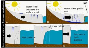
The acceleration of glaciers on the Southern Patagonian Icefield (SPI) can be driven in two distinct ways: from the top-down, or the bottom-up (Figure 2a-e). In the top-down scenario, warm air temperatures melt the glacier ice and, when combined with precipitation, the glaciers are inundated with liquid water (Figure 2a). This water flows under the glacier, lubricating the interface between the glacier and the bedrock, and accelerates the glacier due to a decrease in friction (Figure 2b) In the bottom-up scenario, the warm ocean water melts all contacting terminus ice, undercutting the glacier at the waterline and facilitates iceberg calving (Figure 2c,d). This removal of terminus ice decreases the amount of ice that the glacier has to move, thereby also leading to increased glacier velocities due to a decrease in back pressure (Figure 2e). While two end-member scenarios are presented, a combination of mechanisms most often controls glacier acceleration. Recent studies in Greenland have shown that ocean warming has been the controlling mechanism in glacier instability while in Svalbard both ocean and air temperatures appear to balance each other in driving glacier change. However, how quickly the SPI is responding to warmer conditions and the primary mechanisms behind ice mass loss remain important questions to be addressed.
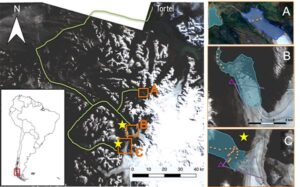
To begin answering these questions, we collected preliminary data on temperature, salinity, surface reflectance, sediment concentration and plankton near the terminus of two tidewater glaciers, Témpano and Bernardo (Figure 1, orange dots). In addition, we installed a time-lapse camera (Figure 1, purple triangles) in Témpano Fjord for 24 hours and another in Bernardo for 72 hours to help us understand fjord surface currents through iceberg movement. A future goal is to leave these cameras in place for months or years to observe trends over longer time periods. In addition, we collected three CTD profiles across a proglacial lake (Figure 1, A) to compliment research by CONAF to monitor the marine organisms in these lakes and fjords and how they are impacted by changing glacial systems in the region.
International Effort:
This collaborative research effort involved members from the United States and Chile from a variety of fields including Glaciology, Conservation, Marine Biology and Oceanography. It is this interdisciplinary approach that will contribute to ongoing research efforts by our collaborators, RRCS and CONAF, to protect an endangered deer species who rely on the recently deglaciated terrain in this region as their last remaining stronghold and to study the impacts of glacial sediment on marine life in these fjord systems. This study will encourage collaborative research between Chilean government agencies, conservation organizations and the UMaine Ice/Ocean Group with the goal of better conserving and managing Chile’s largest national park. We will work with RRCS to increase awareness and participation in this project with local students and teachers living within or near the BONP. Past classroom visits with children aged 8-16 focused on teaching students basic knowledge of glaciers and included boat trips to local tidewater glaciers – a first sighting of the SPI for many of these students despite living in such close proximity all their lives. Based on the positive feedback from participants and parents living in these small communities, we will work with CONAF and RRCS to conduct additional trips to local glaciers within BONP and continue teaching classes on glaciers, wildlife and conservation. An example of past trips can be seen at (https://www.roundriver-blog.org/environmental-education/) showing the success and impact of this community-based conservation approach. This project will also allow undergraduate students from US universities who participate on three-month long programs in Patagonia through RRCS to observe and help with the research since they will already be conducting important endangered deer censuses in the same field locations. With an initial agreement reached between all three organizations to allow UMaine’s Ice/Ocean group to continue research in the Aysen region of Chile, our data can be shared to help in these other projects and highlights the interdependency of the cryosphere and biosphere in this complex environment.
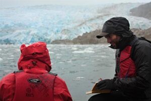
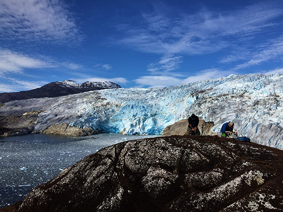
Team members Kristin Schild (left) and Scott Braddock (right) recording CTD data at Témpano Glacier. PC Fernando Iglesias
Media Outreach:
American Alpine Club – https://americanalpineclub.org/meet-our-researchers
Round River Conservation Studies – https://www.roundriver-blog.org/
Climate Change Institute, University of Maine – https://climatechange.umaine.edu/research/expeditions/
Rockridge Venture Law – https://www.venturelaw.org/2019/09/04/partnering-for-protection-collaboration-to-support-climate-action-and-research/
Please contact Scott Braddock (scott.braddock@maine.edu) or Kristin Schild (kristin.schild@maine.edu) with any questions.