
Calibrating Ice Core, Weather Station, and NASA MODIS Ice Surface Temperature Records to Analyze Atmospheric Variability in the St. Elias, Yukon, Canada
Expedition Date: June – August 2018
Field Team Members: Erin McConnell, Karl Kreutz, and Seth Campbell
Expedition Funding: Dan & Betty Churchill Exploration Fund
Expedition Report:
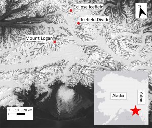
The North Pacific is characterized by complicated atmospheric dynamics, which must be understood to predict the region’s response to a warming climate. Glaciers in the St. Elias Mountains of Canada’s Yukon present an opportunity to reconstruct past climate variability using ice cores. This study aims to quantify the relationships among meteorological data, climate reanalysis models, and ice core records in the St. Elias, focusing on two field sites: Icefield Divide (hereafter referred to as “Divide”) and Eclipse Icefield (“Eclipse”). This analysis will improve our interpretations of ice core records in the St. Elias.
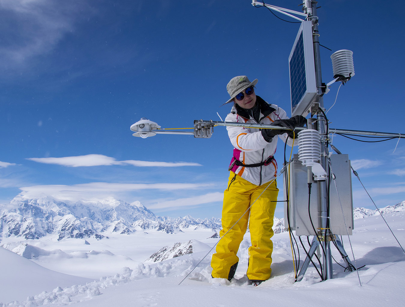
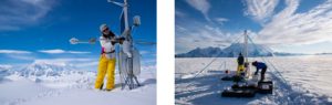
In June 2018, our group (Karl Kreutz, Seth Campbell, and I) completed fieldwork for this project. We drilled two ice cores (10 m and 20 m) at Divide (Figure 1), processed the cores at 10 cm intervals, and collected fresh snow samples from the ice core site. With the help of Douglas Introne in the University of Maine Climate Change Institute stable isotope lab, we analyzed the samples for stable water isotopes (oxygen and hydrogen) using Picarro instrumentation. Isotope measurements are reported in delta notation in reference to the Vienna Standard Mean Ocean Water (V-SMOW) international standard:
δ18O or δD = (Rsample/Rstandard -1) * 1000,
where R represents the ratio of heavy to light isotopes in the sample or standard. Since the distribution of heavy and light isotopes between water vapor and the precipitation that condenses from it is dependent upon the air temperature during condensation, isotope measurements from ice core samples give information about an area’s temperature history. In addition, an automated weather station (AWS) has been in place at Divide since 2002 and is maintained by researchers at the University of Ottawa, with data downloaded directly from the Data Garrison online database. The weather station collects hourly air temperature measurements, as well as snow depth via a snow depth sounder apparatus attached to the station. The location of this station near the ice core site provides a unique opportunity to compare proxy and instrumental records. Our group has also collected ice cores from Eclipse Icefield (Figure 1) in 2017, 2016, and 2002 and analyzed them for stable isotopes and ions. We manually derived a chronology of stable isotope fluctuations for each core using the Ice Core Dater software developed by the University of Maine’s Climate Change Institute. For the 2002 core, volcanic records (Yalcin et al., 2007) provided a check on the core chronology. Additionally, the StratiCounter layer counting software (Winstrup et al., 2012, released 4/30/2015) assisted in dating the 2016 core.
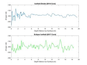
Evidence from the two sites shows important site-specific characteristics: (1) at Divide, strong reflectance at approximately 30 m depth in images from a 400 MHz cross-glacier radar transect, and (2) a larger range of isotope values at Divide (18.4 and 151.0 ‰ for d18O and dD, respectively) than at Eclipse (15.0 and 120.9 ‰) for cores of similar length, with the isotopic range at Divide decreasing with depth (Figure 2). We interpret these differences as evidence of an aquifer at the firn-ice transition at Divide, which results in meltwater percolation that causes the seasonal isotope signal to deteriorate below the 2017/2018 snowpack. This presents a challenge in calibrating the Divide ice core record with instrumental data, since an accurate ice core chronology is required for such a calibration—one that cannot be obtained without a strong seasonal isotope signal. The Eclipse site shows no evidence of an aquifer, but this does not seem to be due solely to a temperature difference: given normal atmospheric lapse rates, temperatures should not differ by more than a degree between the two sites. Instrumental temperature records collected over the year 2016-2017 at each of the two sites via the AWS at Divide and an iButton temperature sensor at Eclipse, as well as NASA Moderate Resolution Imaging Spectroradiometer (MODIS) land-surface temperature data, support this. We hypothesize that differences in annual accumulation between Divide and Eclipse could play a role in the presence of the aquifer at Divide.
The remainder of this project will focus on determining which factors influence variability in the Eclipse ice core isotope record and defining the relationship between the isotope record and instrumentally-observed temperatures. This involves analyzing relationships between the isotope record and large-scale climate variables like sea level and mid-tropospheric pressure, which indicate large-scale atmospheric circulation patterns. This will advance the field in allowing for more accurate estimates of temperature using ice core proxies in this region. This is especially important in the St. Elias, as isotope signatures can be affected by the area’s complicated atmospheric dynamics and topography.
Link to St. Elias Video
https://maine.app.box.com/s/66pwb1tvfsunsa3o3m5gnb33ak23yyoi