
A Multi-Proxy, Millenial-Scale Assessment of Climate, Vegetation, Fire, and Human Impacts in Jamaica, West Indies
A Multi-Proxy, Millennial-Scale Assessment of Climate, Vegetation, Fire, and Human Impacts in Jamaica, West Indies
Fieldwork team members: Mario Williams (Lead Investigator, M.S. Ecology & Environmental Sciences Candidate, Climate Change Institute, University of Maine, USA); Andrea Nurse (Paleoecology Research Associate, Climate Change Institute, University of Maine, USA); Romario Anderson (MPhil Candidate, Department of Geography and Geology, University of the West Indies, Mona, Jamaica); Kadane Coates (MPhil Candidate, Department of Chemistry, University of the West Indies, Mona, Jamaica); Patrick Lewis (Herbarium Curator, Department of Life Sciences, University of the West Indies, Mona, Jamaica)
Report author: Mario Williams
Millions of tourists from all over the world visit Jamaica each year to unwind and enjoy the delectable cuisine, rhythmic musical offerings, and seemingly unending miles of brilliant white sand beaches. Often lost in this milieu of fun, sun, lounging and dancing, on the part of both global visitors and homegrown Jamaicans, is an informed recognition of the rich cultural diversity of the island, which reflects Jamaica’s colorful ecological, environmental and ethnohistorical past. For example, areas such as the Cockpit Country in central-western Jamaica and the Blue Mountains in the east are widely known for exceptionally high species endemism and thus, hold significant local and global ecological value. This immense diversity of plant and animal life was shaped over millennia not only by environmental upheavals, such as sea level changes, fluctuations in hurricane activity, and climate oscillations, but also by the activities of settlers who have colonized the island over prehistoric to historic times. They include early Amerindian groups like the Taino, European explorers searching for bold new lands, and Africans who were first brought to the island to cultivate large expanses of sugarcane and other crops for export. The island’s varied past, punctuated with waves of colonization and different periods of transformative sociocultural change, has resulted in the formation of a fascinating natural landscape that piques the curiosity of the researcher and layman alike.
We conducted fieldwork in Wallywash Pond, Saint Elizabeth, Jamaica from February 1, 2018 to February 10, 2018. The primary objective of this expedition was to collect lake sediment cores from Wallywash Pond in order to test hypotheses related to past cultural and landscape changes on the island. Lake sediment cores contain environmental materials (a.k.a “proxies”) that accumulate in a chronologically ordered fashion and can provide valuable insights into the history of human occupation for a region, the main drivers of landscape change, or climate variability over various time and geographic scales. The focus of my project is twofold—I aim to investigate the response of Jamaican vegetation communities to past natural and human perturbations, such as climate and land use changes respectively; and to better constrain the timing of first human arrival on the island. The exploration of these topics will provide information pertinent to forming novel understandings about the island’s prehistoric environmental and cultural development, and also to the determination of viable strategies for conserving Jamaica’s biodiversity—particularly in light of recent, accelerating global temperature changes. For example, an improved understanding about the colonization history of the island and associated periods of landscape change will provide us with knowledge that will help establish reference conditions for setting restoration targets and support efforts for protecting vulnerable species. Furthermore, better information about how plant communities responded to climate oscillations throughout the Holocene will provide environmental managers with the data necessary to help mitigate undesirable future biodiversity outcomes, and better safeguard the livelihoods of local peoples who depend heavily upon the island’s natural resources. This project is the first of its kind in Jamaica, and one of only a few in the insular Caribbean region, to place millennial-scale vegetation shifts in the combined context of prehistoric climate changes and more recent anthropogenic landscape modifications e.g. agricultural expansion, land clearance, and urbanization.
Wallywash Pond is the largest freshwater lake in Jamaica and is located on the southwestern coast close to the town of Black River. I chose Wallywash Pond to be the field location for this study because of its relatively large size, close proximity to previously discovered indigenous archaeological sites, and the existence of previous scholarly work that has been conducted at the site. These factors increase the probability of both detecting and understanding the environmental changes that I am examining in the Wallywash Pond sedimentary record and will contribute to the placement of my findings in the broader context of past Jamaican cultural and landscape evolution. Wallywash Pond has an average depth of approximately 3 m and a maximum depth of 5 m. The lake is also located on the southeastern boundary of the Black River Lower Morass (BRLM), which is listed as a wetland of international importance under the Ramsar Convention. The BRLM and its associated waterways provide habitat for a diversity of wildlife species, including the American crocodile (Crocodylus acutus) and West Indian manatee (Trichechus manatus), and several species of resident and migratory waterfowl such as the Blue-winged teal (Anas discors), American wigeon (Anas americana), Black rail (Rallus jamaicensis), West Indian whistling duck (Dendrocygna arborea), and Yellow breasted crake (Porzana flaviventer).
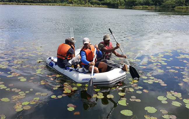
Fieldwork began when myself and Andrea Nurse met with Romario Anderson and Kadane Coates in Black River, Jamaica. We spent the first day scouting the field site to ensure that we had proper access to the lake, and also to determine the most suitable location from which to collect our sediment cores. The next few days were utilized for actively coring the lake. Two sediment cores, each measuring approximately 4 m, were collected from the northern basin of Wallywash Pond using a 2-inch Livingstone piston corer; although several coring drives were made using a Bolivia adapter and polycarbonate tubes. The sediment cores were then wrapped securely and stored in preparation for shipment to the National Lacustrine Core Facility (LacCore) in Minnesota, USA. Myself, Andrea Nurse and Patrick Lewis then conducted a survey of the local vegetation. Common aquatic vegetation found in the lake included Potamogeton and Nymphaea. The lake margin was dominated by a variety of sedges, including Eleocharis, Cyperus and Cladium, and dense stands of Typha. The upland vegetation was dominated by several grasses and herbs, logwood (Haematoxylum campechianum) and mesquite (Prosopis juliflora) trees, and dense thickets of pepper rod (Croton humilis). After completion of the vegetation survey, the sediment cores were shipped off the island to their final destination in the USA. Andrea and I said goodbye to our amazing and incredibly helpful collaborators in Jamaica and we departed the island en route to Bangor Airport in Maine.
At LacCore, I split the sediment cores and took high resolution digital images to document sediment color, core stratigraphy, and other important features of the collected core material, including the presence of preserved plant matter and the calcium carbonate-rich shells of freshwater gastropods and mollusks. In addition to this information, I collected geophysical and geochemical data, including magnetic susceptibility and electrical resistance, which will complement the biological proxy data that I will later generate from the sediments. Half of each of my sediment cores was archived by LacCore at their storage facility, and the other half was shipped to the University of Maine for laboratory analyses. I am currently in the process of generating and analyzing biological proxy data from the working halves of my sediment cores. These data include pollen and charcoal counts, which will inform us about vegetation and fire trends respectively, and ostracod stable oxygen isotope data. The ostracods were picked from the sediment at the University of Maine Climate Change Institute and have been submitted to the University of Arizona Environmental Isotope Laboratory for analytical processing.
I thank Andrea Nurse, Romario Anderson and Kadane Coates for their assistance with this fieldwork, including the transportation of coring equipment while at the field site and sediment core collection. I thank Patrick Lewis for his help with plant identification and classification during the vegetation survey. I also thank my graduate advisor, Dr. Jacquelyn Gill, and Dr. Michael Burn of the University of the West Indies, Mona, for providing technical and logistic support throughout the duration of this project. I am indebted to many other colleagues, friends and family, who through their thoughtful words and sound suggestions, helped me immensely to complete this expedition. Financial support for this research project was kindly provided by the Dan and Betty Churchill Exploration Fund, the National Lacustrine Core Facility, and many generous donors on Experiment.com. I express my sincere gratitude to all of the individuals and institutions listed above for helping me to complete this work, and I look forward to sharing my findings as the project progresses.
-
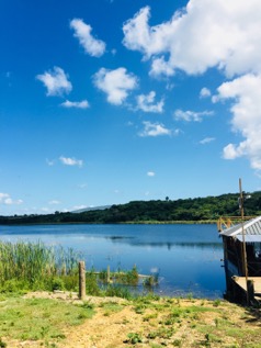
- A view of Wallywash Pond, Saint Elizabeth, Jamaica, from which we collected sediment cores in early February 2018.
-
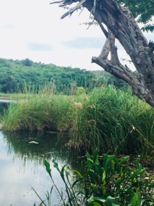
- Vegetation bordering the Wallywash Pond shoreline. A survey of the vegetation surrounding the lake was a critical component of this expedition.
-
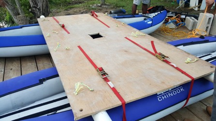
- The platform used to facilitate collection of the sediment cores during fieldwork. The Livingstone piston corer was lowered to the lake bottom through the small hole in the center of the platform. The platform was kept stable during coring with the use of four cement blocks secured to its corners and then sunk to the lake bottom.
-
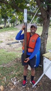
- Mario Williams (Climate Change Institute, University of Maine) holding a sediment core collected from Wallywash Pond, Jamaica.
-
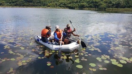
- Mario Williams (Climate Change Institute, University of Maine), Kadane Coates (Department of Chemistry, University of the West Indies, Mona) and Romario Anderson (Department of Geography and Geology, University of the West Indies, Mona) transporting a freshly collected sediment core to shore.
-
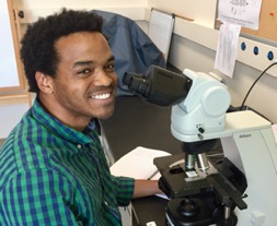
- Pollen, charcoal, and other biological proxies preserved in the collected sediments are quantified using a microscope in the laboratory setting to learn about past environmental changes.
-
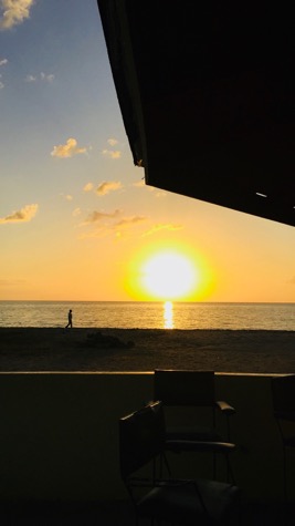
- A picturesque view of the setting sun and glistening Caribbean Sea from our lodging in Jamaica.