Spatial Extrapolation of Melt and Mass Balance in the Central Alaska Range
Spatial Extrapolation of Melt and Mass Balance in the Central Alaska Range
Dominic Winski, Seth Campbell, Kristin Schild
May 9 – June 8, 2011
Funding for this project was generously provided by the Dan and Betty Churchill Exploration Fund.
The primary goals of the 2011 field expedition are as follows:
1. Collect data on changes in temperature, humidity and radiation with altitude.
2. Measure snowpack water content in relation to altitude and compare to model results.
3. Collect ground penetrating radar data on Mt. Hunter Plateau.
4. Collect radiogenic nuclide data from Mt. Hunter Plateau.
These projects are necessary for the completion of Dominic Winski’s master’s degree, Seth Campbell’s PhD, and John Thompson’s undergraduate honors thesis. This will also add to ongoing ice core paleoclimatology work done at the University of Maine.
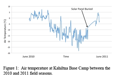
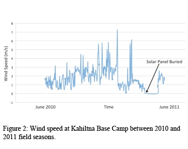
As in previous years, our first step was to reset the weather station that had been installed two years previously at Base Camp. This task was particularly difficult this year, as the station had collapsed during the winter. Nevertheless, we were able to extract, repair, and re-anchor the station and recover nearly all of the year’s data.
Once the weather station at Base Camp (elev. 7000 feet) was established we climbed to 14000 feet above sea level, carrying with us a second weather station. This station collected meteorological data synchronously with the Base Camp station so that we are able to form relationships between altitude and temperature, humidity and radiation. We found that radiation increased at high altitudes, temperature decreases with altitude and humidity peaked at around 10000 feet above sea level, falling off slowly to either side. These results are important in order to be able to model and understand the melting of snow on glaciers in the Alaska Range.
While at 14000 ft. camp, we collected ground penetrating radar data showing that the ice thickness in this location was up to 250 meters. On the descent to Base Camp, we measured the water content and density of the top one meter of the snowpack in 1000 foot intervals. Though unprocessed, we hope that this data will show the upper elevation limit to melting in the Central Alaska Range during early summer.
Acclimatized from our experience at 14000, we then flew to an ice divide on Mt. Hunter to collect additional meteorological measurements, ground penetrating radar (GPR) data, and radiogenic nuclide samples. The team collected a grid of GPR profiles at 900, 100, and 40 megahertz providing the bed topography and information regarding internal stratigraphy and deformation. Additionally, we measured the velocities across the Mt. Hunter Plateau, which will be used to model strain rates relating to crevasse formation at this site.
Dom Winski departed on June 6, after which time Seth Campbell and John Thompson remained on Mt. Hunter Plateau to collect the chemistry data. Though not yet processed, this data will inform our knowledge of where the Fukushima fallout has reached and, more broadly, how atmospheric circulation processes function.