Roosevelt Island Climate Evolution (RICE)
Roosevelt Island Climate Evolution (RICE)
Roosevelt Island, Antarctica
Second Field Season: 10/10/2011 – 01/19/2012
Funding: National Science Foundation and GNS Science
Webpage written by Thomas Beers
RICE is an international collaboration between New Zealand, USA, Denmark, United Kingdom, Germany, Australia, Italy and China. The aim of the project is to recover a 750 m deep ice core from Roosevelt Island in Antarctica to determine the stability of the Ross Ice Shelf and West Antarctica in a warming world (Dr. Nancy Bertler, Chief Scientist).
Victoria University of Wellington’s RICE webpage, including a list of all parties involved:
http://www.victoria.ac.nz/antarctic/research/research-prog/rice/
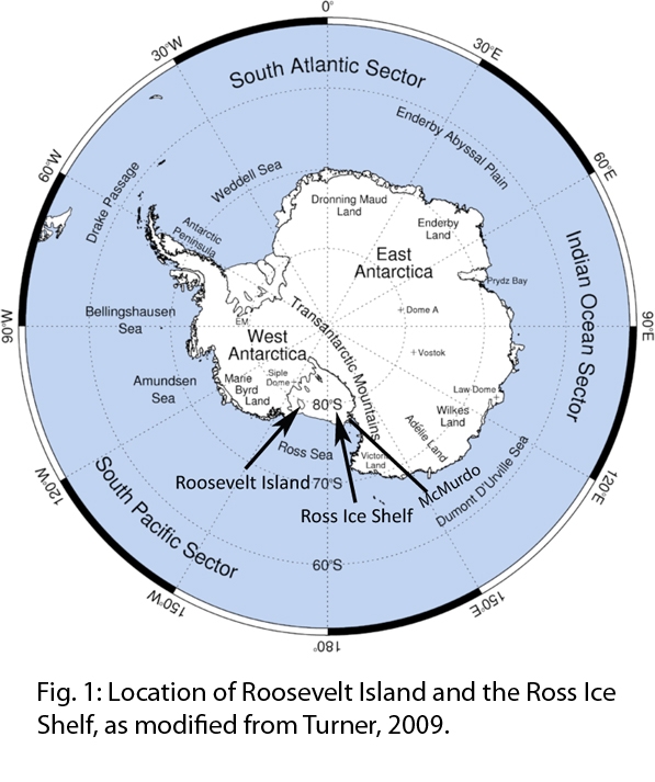
Roosevelt Island is the northern most location that an ice core can be recovered on the Ross Ice Shelf (Fig. 1). Its proximity to the Ross and Amundsen Seas makes it an ideal location to record changes in sea ice extent as well as atmospheric circulation patterns, and their impact on the ice shelf and the West Antarctic Ice Sheet.
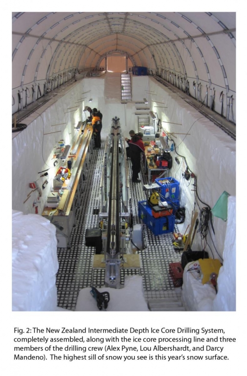
As a National Science Foundation Grantee, I worked as an ice core processor this field season, along with two other team members, Andrea Logan and Daniel Emmanuelsson. For the first few weeks I assisted the team with setting up and digging the drilling trench (Fig. 2) as well as sampling surface snow daily, and doing maintenance work around the camp.
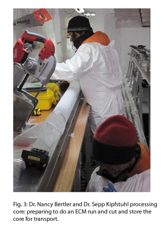
When the drilling began, I worked as an ice core processor with fellow graduate students under the direction of Dr. Nancy Bertler and Dr. Sepp Kipfstuhl. This consisted of measuring the ice core to ensure the correct depth, taking temperature measurements, as well as ECMs (Electrical Conductivity Measurements) to give a first glimpse at the impurity signals preserved in the core (Fig. 3). It is also crucial that the correct orientation be kept between breaks for later studies, thus we struck a line down the core and across breaks to preserve the original configuration. Finally, the core had to be cut into meter long sections for transport back to the lab.
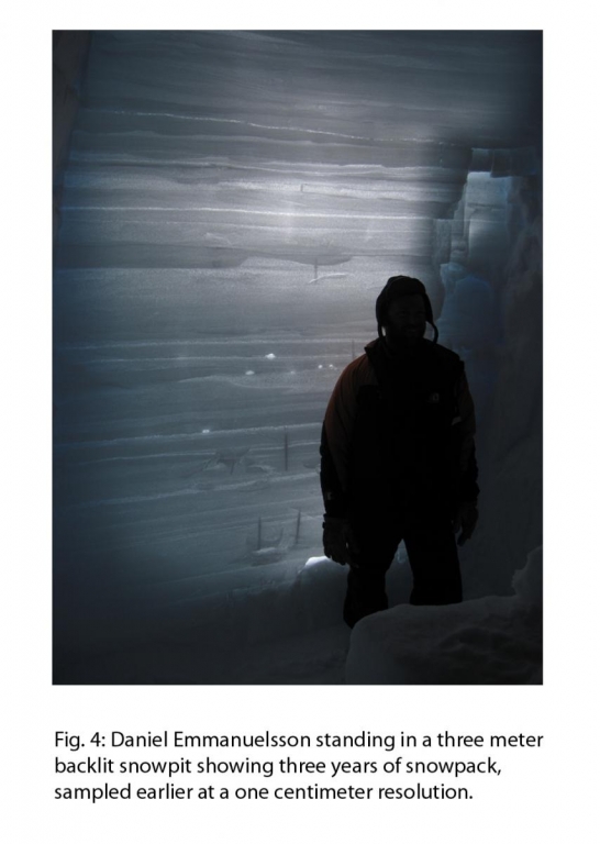
We also drilled three shallow cores with a hand operated Pico Drill to sample the snow and firn that was not collected by the larger drill because of the depth of drill trench. These shallow cores (~11 m) overlap with the deep ice core to get a complete record dating to the present day. For higher resolution data we collected samples every centimeter for three meters by digging a snowpit and scraping snow and firn into vials for processing later (Fig. 4).
As drilling came to an end for the season, team members assisted with collecting mass-balance data with Professor Howard Conway in a 200 km2 grid over Roosevelt Island (Fig. 5). We also arranged the winter cargo line to keep drifting to a minimum around our camping area and winterized the drill tent and other systems for next season.
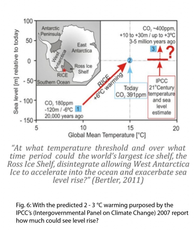
As a team, we drilled 130 meters of ice this field season, which covers approximately the last 500 years, and will hopefully drill to bedrock next season. Ice core processing is scheduled to begin this August, both in New Zealand at the New Zealand National Ice Core Research Facility at GNS Science, as well as the Climate Change Institute at the University of Maine. We will be analyzing this core for fluctuations in element concentrations, isotopes, trace elements and greenhouse gases, which should tell of past impacts of climate on the Ross Ice Shelf and West Antarctic Ice Sheet. Through reconstructions of weather systems, such as the Amundsen Sea Low, we can study how the Ross Ice Shelf has reached its current state, and predict how it will react in the future (Fig. 6).
We will be analyzing this core for fluctuations in element concentrations, isotopes, trace elements and greenhouse gases, which should tell of past impacts of climate on the Ross Ice Shelf and West Antarctic Ice Sheet. Through reconstructions of weather systems, such as the Amundsen Sea Low, we can study how the Ross Ice Shelf has reached its current state, and predict how it will react in the future (Fig. 6).
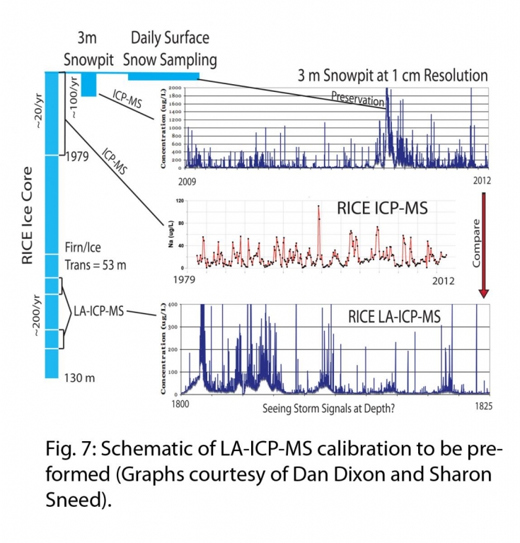
The Climate Change Institute will be using some of the top sections of this core to calibrate the Keck Laser Ice Facility LA-ICP-MS (Laser Ablation-Inductively Coupled Plasma-Mass Spectrometer). This calibration will be preformed with the comparison of snowpit data to past weather data (1979 to present) to LA-ICP-MS data see if we are really seeing storm signals at depth in ice core records (see fig. 7). This newly developed instrument is could possibly resolve sub-seasonal fluctuations in weather patterns and sea ice extent into the distant past.
Please read the expedition blog from the 2011/2012 field season for a weekly account of progress:
http://www.victoria.ac.nz/antarctic/research/research-prog/rice/field-season-blogs
Map modified from:
Turner J. et al. (2009): Antarctic Climate Change and the Environment. Scientific Committee on Antarctic Research. 2.