
Human Adaptations to Climate Change on the North Coast of Peru: Satellite, Survey, and Geophysical Investigation of Archaeological Sites
Human Adaptations to Climate Change on the North Coast of Peru: Satellite, Survey, and Geophysical Investigation of Archaeological Sites
Field Team Members: Ani St. Amand
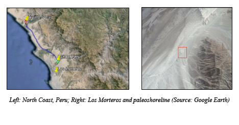
Chao Valley, Peruvian North Coast July 24 – August 4, 2016
Funding Support: Dan & Betty Churchill Exploration Fund
Research Background
Like many places on Earth, human populations on the North Coast of Peru have long been impacted by climatic events that shaped where they lived, how they interacted with the environment, and the resources they extracted. In this region, El Niño is a major factor in human-landscape interactions. Associated with extreme weather events (flooding, landslides, changes in biotic resources) and unusually warm ocean temperatures along the Peruvian coast, El Niño generally occurs today every 3-8 years. In the past (5,800-3,000 years before present [BP]), events were less frequent, and prior to 5,800 BP, there appears to have been a several thousand-year hiatus of El Niño in the climate record (Sandweiss et al., 2007).
The goal of my research expedition was to better understand how humans in the Chao Valley on the North Coast responded to abrupt climate and environmental change during the mid-Holocene, particularly in the time period associated with the mid-Holocene onset of El Niño. I conducted field work at Los Morteros, a sand-covered archaeological site in this region, selected because this site may have been constructed by humans in response to changing climates. Once thought to be a natural formation, researchers from the Climate Change Institute used ground penetrating radar (GPR) to prove that this large, isolated mound hides mid-Holocene structures built by early occupants of the region (Mauricio, 2015; Sandweiss et al., 2010). Excavations of this 225m x 200m feature indicate periods of construction and occupation during several distinct intervals, beginning before 5,800 years ago, with progressively younger structures built on top of older features buried by sand (Mauricio, 2015). Radiocarbon dates suggest the most recent phase of construction occurred between 5,500 and 5,100 BP. This places construction of Los Morteros near the beginning of the cultural practice of monumental construction on the North Coast, with important implications: dramatic climate changes are linked to early monumental architecture in Peru, which apparently began and terminated with these climate transitions ca. 5800 – 3000 BP (Sandweiss et al., 2007; Sandweiss et al., 2009).
Research Goals
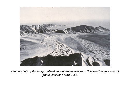
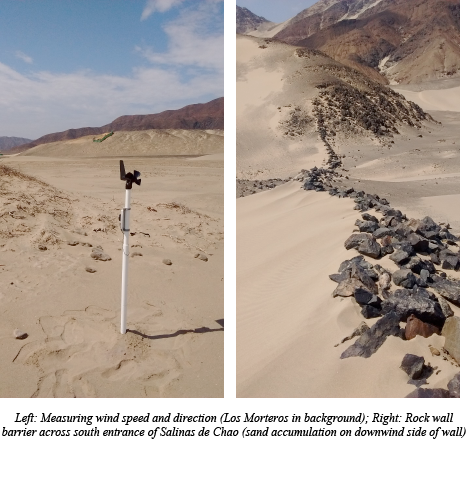
Before traveling to the North Coast, I developed two primary research hypotheses relating to human adaptation and climate in the Chao Valley. The first hypothesis was that the builders of Los Morteros took advantage of strong winds in the Salinas de Chao to help accumulate sand to intentionally bury their structures (thus increasing height and size of the mound). My second hypothesis was that other, unknown sites – similar to Los Morteros – exist hidden beneath nearby coastal dunes. To assess these hypothesis, I conducted surveys of the dry, barren Salinas de Chao, where Los Morteros is located. Today, the valley contains many chicken farms, with large structures and roads crisscrossing the desert landscape. A large paleo-shoreline gently curves through the valley, with Los Morteros located right at its edge.
Results and Discussion
I used an anemometer study to understand wind patterns in the Salinas de Chao by measuring wind velocity (speed and direction) across Los Morteros in a closely-spaced grid, and at more dispersed locations throughout the valley. I collected measurements to serve as input for my computational fluid dynamics (CFD) model produced in OpenFOAM software, and a subset served to validate these wind models. Other inputs included digital elevation models (DEMs) and a high resolution topographic map of Los Morteros produced by CCI graduate Kurt Rademaker.
By using OpenFOAM to model wind patterns across the valley, I have been able to understand natural sand transport potentials, as well as to address as a primary question: could Los Morteros have formed naturally? Or was human intervention (such as the construction of walls perpendicular to the predominant wind direction, as well as flagstone surfaces) necessary to accumulate the large quantities of sand that partially compose this mound? Results (including maps of depositional and transport potentials across the landscape) indicate that under the most likely mid-Holocene climate scenarios for the Chao Valley, this mound could not have formed without human modification of the landscape. Future work, including the integration of GPR data with CFD models, can further our understanding of the intentions of builders of this site: were structures intentionally created from the beginning to accumulate sand, or was the buildup of sand noted and then later exploited?
I also addressed the second component of my research: improving my semi-automatic land cover classifications of the valley via surveys to confirm or reject preliminary classifications I created. Initial classifications were created using Landsat satellite images and DEMs. Images were evaluated for spectral signatures on the basis of reflectance and absorption properties of materials, and spectral indexes were used for identification of features such as vegetation, rock outcrops, and water bodies. Spatial aspects (feature shape rather than material) were also analyzed using edge detection and other techniques with the aim of identifying structures, walls, and sand dune features. Digital elevation models were incorporated to evaluate terrain slope and to discriminate between features based on height differences. Visual identification was also used to identify points of interest; these were included in a separate map. Ultimately, the moderate resolution of Landsat images (30m) was the limiting factor in my semi-automated classifications, but ‘groundtruthing’ enabled me to refine my land cover assessments with the goal of creating maps to identify potential buried archaeological sites in the valley.
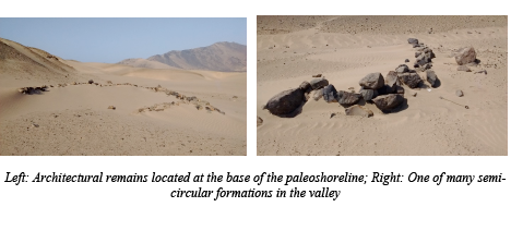
In the Salinas de Chao, I visited locations I had identified as potential buried sites, and recorded the extent and characteristics of natural landscape formations such as dunes, rock outcrops, and vegetation. This was important because classification maps should include not only human-made features but must also be able to identify categories of natural features to reduce their false classification as archaeological sites. Not surprisingly, I found that the 30m resolution of my satellite data prevented the semi-automated identification of smaller features in the landscape, such as the smaller, geometric rock formations located throughout the valley (below), with average sizes well below 30m.
Surveys allowed me to refine my landcover categories by eliminating falsely-identified features from my spectral categories, and by adding additional surveyed features to these datasets. Importantly, I found that visual identification of archaeological sites using high resolution (1-2m) satellite images (without spectral bands) available through Google Earth had a high success rate because these smaller features were apparent at this scale. While the locations of many low-profile, human-made geometric rock formations were confirmed via survey (some were partially buried by sand), no large mounds like Los Morteros were identified in the immediate area, confirming the importance of this archaeological site. In the future, remote identification of archaeological sites using a combination of semi-automated land cover classification and visual identification techniques will continue to be useful in identifying potential archaeological sites for investigation, but limitations of resolution make it clear that semi-automated methods can be greatly improved by the collection of spectral and spatial data using a drone equipped with a multi- or hyperspectral camera.
Acknowledgements
This field work is a component of my Master’s Thesis through the CCI, and is part of ongoing climate-based and geoarchaeological research on the North Coast by my advisors, Alice Kelley and Dan Sandweiss. I would like to thank the Dan & Betty Churchill Exploration Fund for providing a grant to cover the cost of this expedition. This generous contribution from the Churchills made this trip possible, as did support from the Climate Change Institution at the University of Maine. This field work was also made possible by Cecilia Mauricio Llonto, alumna of UMaine and CCI. Cecilia was working at Los Morteros during my visit to Peru and kindly provided housing and transportation to and from the site during my research. Her expertise and hospitality were invaluable. And as always, thanks to Betty Lee and Rebecca Addessi for their assistance with any and all logistics during the planning and execution of this field work.
References
Kosok, Paul (1965). Life, Land and Water in Ancient Peru. New York: Long Island University Press.
Mauricio Llonto, A. C. (2015). Los Morteros: Early monumentallity of environmental change in the Lower Chao Valley, Northern Peruvian Coast (Unpublished doctoral dissertation). University of Maine, Orono, ME.
Sandweiss, D. H., Maasch, K. A., Andrus, C. F. T., Reitz, E. J., Riedinger-Whitmore, M., Richardson III, J.B., & Rollins, H.B. (2007). Chapter 2: Mid-Holocene climate and culture change in coastal Peru. Climate change and cultural dynamics: A global perspective on Mid-Holocene transitions, 25-50.
Sandweiss, D.H., Shady, R.S., Moseley, M.E., Keefer, D.K., and Ortloff, C.R., 2009. Environmental change and economics development in coastal Peru between 5,800 and 3,600 years ago: Proceedings of the National Academy of Sciences of the United States, Vol. 106, p. 1359-1363.