
Hot or Cold? Assessing “seasonality” during the paradoxical Heinrich Stadial 1 using glacier geochronology in northwest Scotland
Hot or Cold? Assessing “seasonality” during the paradoxical Heinrich Stadial 1 using glacier geochronology in northwest Scotland
Field team members: Allie Balter1,2, Holly Thomas2, Gordon Bromley1,2, Steve Barker3
1. Climate Change Institute, University of Maine
2. School of Earth and Climate Sciences, University of Maine
3. School of Earth and Ocean Sciences, Cardiff University
March 5th to 17th, 2017
Funding Support: Dan and Betty Churchill Exploration Grant, Comer Family Foundation, and the National Geographic Society
Fieldwork Report
Background
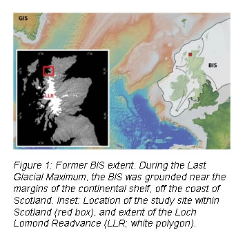
This expedition to Scotland was a continuation of work that Dr. Gordon Bromley began in 2015. Our goal for this project is to reconstruct the behavior of the former British Ice Sheet (BIS) during the last “termination” (19-11 ka), when the earth emerged from the last ice age. Paleoclimate records indicate global temperature increased in step-wise fashion, with warming punctuated by abrupt millennial-scale cooling events [1]. Notable short-term climate oscillations throughout deglaciation include cool “Henrich stadials” 1 (HS1; 18.3-14.7 ka) and 0 (Younger Dryas; 12.9-11.6 ka), which were separated by an apparently warm “interstadial” known as the Bølling-Allerød. Crucially, the transitions into and out of Heinrich stadials were abrupt [2]. It is well established that the former British Ice Sheet (BIS) began retreating ~20 ka [13-15]; after that the paleoclimate data are conflicting. Permafrost expansion in northern Europe [16] and low mean annual air temperatures (MAT) in Greenland [17] indicate that HS1 was a cold period in the North Atlantic. Conversely, recent marine data suggest that Europe’s ice sheets were retreating during HS1[18], signaling that this may have been a warm, rather than cold, period. These two models appear incompatible: one suggests that HS1 was cold, while the other indicates that HS1 was a time of warming and deglaciation. A third model remains untested: HS1 may have been a period of high “seasonality,” in which winter temperatures were cold, but summer temperatures were relatively warm [19].
Ice sheets and glaciers are iconic indicators of climate, as they wax and wane primarily in response to summer air temperature [20]. We will test the seasonality model by reconstructing former BIS retreat and subsequent alpine glaciation in northwest Scotland using beryllium-10 surface-exposure age dating of moraines and erratic boulders, offering a terrestrial complement to existing marine data. Based on a pilot study by Dr. Gordon Bromley (project PI), glacial erratics in this region capture BIS retreat from the North Atlantic to the ice sheet’s source in the Grampian Mountains [23]. Cirques in the highlands exhibit clear moraines, evidence of a subsequent readvance called the “Loch Lomond Readvance” (LLR). By dating erratics, which would have been dropped by the retreating BIS, we will help resolve the timing and characteristics of ice-sheet retreat from the coast to the Grampian Mountains (i.e. warm summer air temperatures). If we find that BIS readvance or stabilization coincided with HS1, it will indicate that HS1 was indeed a cold period in the North Atlantic. Conversely, if Scotland’s glaciers retreated during HS1, it will suggest that abrupt stadials are characterized by warm summers, despite apparently cold winters. Additionally, we will provide ages for the cirque moraines to help resolve when the LLR occurred (i.e. cold summer air temperatures) in relation to stadial conditions.
Fieldwork
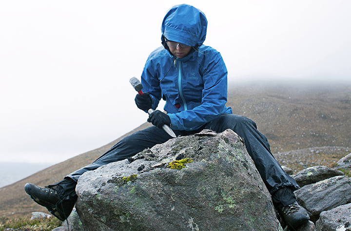
During this expedition, we visited five field sites in northwest Scotland where we mapped glacial features and collected rock samples for surface exposure-age dating: a sedimentary sequence in Gartness, the Aultbea moraine, Mac is Mathair/Coire Mor An Teallaich, Beinn Dearg Beag, and Ben More Coigach.
Gartness Sedimentary Section
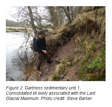
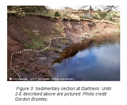
In Gartness, a cut bank of the Endrick River exposes a ~10 m high sedimentary sequence. We observed 6 distinct sedimentary units (Figures 2 and 3), described below in order from strategraphically oldest to youngest:
Unit 1: Consolidated till with red clay matrix. Random fabric. Clasts are sub-angular and striated. We interpreted this unit as a till from BIS overriding of this area during the last glaciation. See Figure 2.
Unit 2: Marine clays. Alternating pink and grey beds. Small bivalve shells were found. Inferred to be marine clays deposited by shallow seas that inundated this area as the BIS retreated. See Figure 3
Unit 3: Medium-grained sand with some instances of laminated sand, silt, and clay within the unit. As ice readvanced during the Loch Lomond Readvance, it dammed a lake (known as Glacial Lake Blane) in this area. We interpret these sands as having been deposited in that lake. See Figure 3.
Unit 4: Bedded gravels and sand. Clasts are rounded. Coarsening upwards. We interpret these as fluvial (meltwater) deposits deposited during a readvance of the glacier. As the glacier margin advanced towards Gartness, the site would have received coarser materials from the meltwater rivers, until the glacier finally reached Gartness. See Figure 3.
Unit 5: Till with red clay matrix. Random fabric. Clasts are sub-angular and striated. Similar to Unit 1, but slightly less consolidated. We infer this till layer to be from the Loch Lomond Readvance. See Figure 3.
Unit 6: Laminated rusty clays with some organic material and gravel to boulder-sized dropstones (ice rafted debris). This unit was likely deposited in an ice-dammed lake, when the glacier was still close enough to discharge icebergs into the lake. These icebergs would have deposited dropstones. See Figure 3.
In Figure 3, it is clear that all sedimentary units below Unit 6 have been tilted and deformed. This deformation would have occurred as ice readvanced over previously deposited sediments. However, Unit 6 is not deformed because it was never overridden by ice. To test the hypothesized ages of the sedimentary units, we collected several sediment samples from each unit. We will sift through these samples for organic material that we can use for radiocarbon dating.
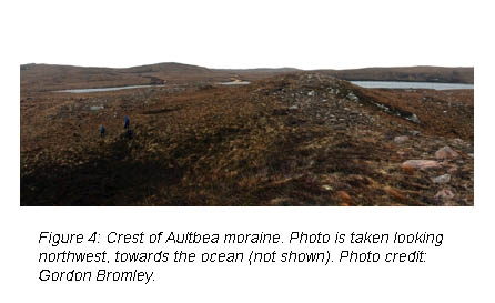
Aultbea Moraine
As the former BIS retreated from its maximum extent following the last glacial maximum (LGM; ~20 ka), it paused near the present-day coastline to form the Aultbea moraine (Figure 4). To constrain the timing of BIS retreat, we collected samples from three erratic boulders perched on bedrock outside of (ice-distal to) the Aultbea moraine, and seven samples from the moraine itself. Ages of the erratic boulders will document when the BIS margin retreated onto the land. The ages of the Aultbea moraine will tell us when the BIS retreated began to retreat further inland from the moraine.
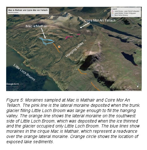
Mac is Mathair and Coire Mor An Tellach
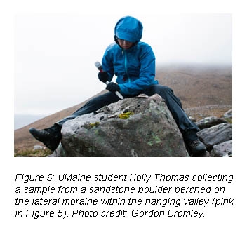
The moraines present at this site capture several stages of deglaciation. The Mac is Mathair and Coire Mor An Tellach cirques are located on high slopes above a large hanging valley. We found moraines indicating that as the BIS thinned, a large glacier was still present in the hanging valley. Evidence of this comes from a large lateral moraine on the southeast side of the valley (pink in Figure 5). Next, we saw evidence that the glacier retreated from this hanging valley, but still occupied Little Loch Broom. This glacial configuration was evident from a large lateral moraine on the southwest side of Little Loch Broom, which continues seaward past the mouth of the hanging valley (orange in Figure 5). Lastly, we saw that moraines deposited by the cirque glacier in Mac is Mathair (blue in Figure 5) overlie the large lateral moraine on the southeast side of Little Loch Broom. These moraines in Mac is Mathair are evidence of a readvance of cirque glaciers after the BIS had largely retreated from this region. We collected ~5-7 samples for beryllium-10 surface exposure-age dating from each of these moraines (Figure 6).
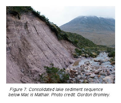
Below Mac is Mathair (in the hanging valley), a river cuts into the hillside, exposing an ~10 m high lake sediment sequence (Figure 7). This lake sequence has horizontal red and white bedding, is highly consolidated, and is fractured in some places. Till, which stratigraphically correlates with the Last Glacial Maximum, overlies the lake sequence. These lake sediments, evident of a large glacial lake, should have also outcropped on the other side of the hanging valley. However, they were not observed elsewhere in the valley. Due to the consolidated and brittle nature of these lake sediments, and the fact that the sediments are overlain by till that is likely from the Last Glacial Maximum, we hypothesize that this glacial lake predates the Last Glacial Maximum. While we would usually expect that these older sediments to be stripped by the BIS as it overrode this area, it is possible that the sediments were preserved under a minimally erosive “pocket” of the ice sheet. We collected sediment samples of the lake sequence with the hope of recovering some organic material for radiocarbon dating.
Beinn Dearg Beag
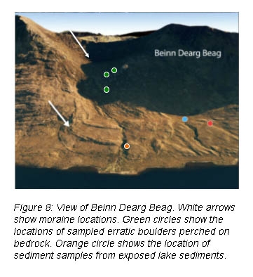
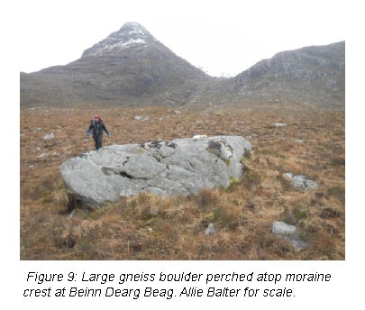
This site has three prominent moraine crests that represent readvances of the glacier that once occupied this cirque (Figure 8). These were mapped as part of the Loch Lomond Readvance, which would have occurred after the thinning and retreat of the former BIS into its source area in the Grampian Mountains. A fourth moraine was found in the cirque, representing the “last gasp” of this glacier. We collected samples from the top surfaces of Lewisian Gneiss and Torridonian Sandstone boulders perched atop the crests of these four moraines (Figure 9). In addition, we collected samples from three erratic boulders between the inner-most lower morane and the upper cirque moraine. Ages of these erratic boulders will capture the up-valley retreat of this glacier.
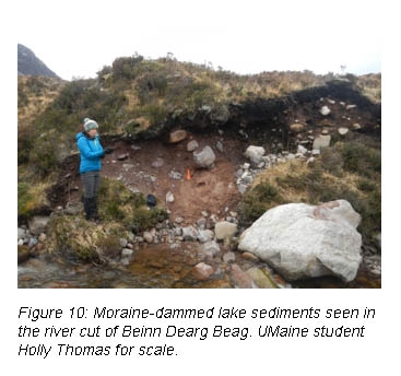
At Beinn Dearg Beag, a modern river dissects the moraines. Exposed in the riverbanks is yet another sedimentary sequence that contains evidence of a moraine-dammed lake, which would have formed as ice retreated into the cirque (Figure 10). Here, we collected several sediment samples from the lake sediment sequences for radiocarbon dating, as we did at Gartness, which will tell us when the moraine-dammed lake occupied the area.
Ben Mor Coigach
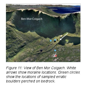
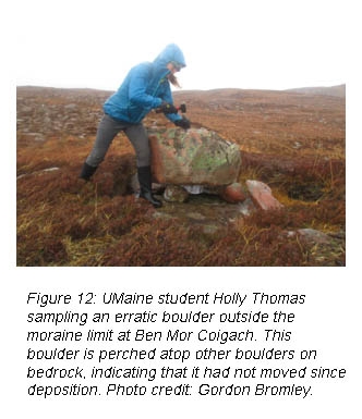
This site was once occupied by a cirque glacier beneath the peak of Beinn an Eoin. Four moraines are present at the base of the cirque, representing pulses of this cirque glacier during the Loch Lomond Readvance (Figure 11). We collected samples from each of these four moraines to constrain the timing of retreat from each moraine. We also took samples from several erratic boulders perched on bedrock within the moraine limits, which will show when the cirque as deglaciated. Lastly, we collected samples from several erratic boulders outside of the moraine limits to constrain the timing of BIS retreat into the mountains (Figures 11& 12).
Acknowledgements
Thank you to the Dan and Betty Churchill Exploration fund for travel and field expenses for Allie Balter while in Scotland. Also, thanks to Donald, Jane, and Tim Rice, and Alasdair and Mhairi MacDonald for their hospitality. We would also like to acknowledge the Comer Family Foundation and the National Geographic Society for travel and field expenses for Gordon Bromley, Holly Thomas, and Steve Barker, as well as funds for sample analysis.
References
[1] Bond, Gerard, et al. (1997) Science 278, 1257-1266.
[2] Bard, E., et al. (2000) Science 289, 1321–1324.
[3] Mayewski, P.A., et al. (1997) Journal of Geophysical Research 102, 26345–26366.
[4] Alley, R. (2000) Quaternary Science Reviews 19, 213-226
[5] Wang, Y., et al. (2001) Science 294, 2345-2348.
[6] Blard, P.H., et al. (2009) Quaternary Science Reviews 28, 3414-3427.
[7] DeDekker, P., et al. (2012) Nature Geoscience 5, 266-269.
[8] Schaefer, J.M et al. (2006). Science 299, 1874–1877.
[9] Gosse, J.C. et al. (1995) Science 268, 1329-1333.
[10] Licciardi, J.M. et al. (2004) Geology 32, 81-84.
[11] Kaplan, M.R. et al. (2004) Geological Society of America Bulletin 116, 308-321.
[12] Denton, G.H (1999) Geografiska Annaler 81A, 107-153.
[13] Ridge, J. (2004) Quaternary Glaciations Extent & Chronology, Part II, Elsevier.
[14] Clark, P.U., et al. (2002) Science 295, 2438 – 2441.
[15] Toucanne, S., et al. (2009) Quaternary Science Reviews 28, 1238-1256.
[16] Atkinson, T.C., et al. (1987) Nature 325, 587-592.
[17] Cuffey, K.M., & Clow, G.D. (1997) Journal of Geophysical Research 102, 26,383-26,393.
[18] Toucanne, S. et al. (2015) Quaternary Science Reviews 123, 113–133.
[19] Denton, G.H. et al. (2005) Quaternary Science Reviews 24 (10), 1159-1182.
[20] Oerlemans, J. (2005) Extracting a climate signal from 169 glacier records. Science 308, 675–677.
[21] Bromley, G.R.M., et al. (2014) Proceedings of the National Academy of Sciences 111, 6215–6219.
[22] Ballantyne, C.K. (1987) Wester Ross Field Guide, Quaternary Research Association 72–92.
[23] Bromley, G.R.M., personal communication.