
Nevado-Coropuna Shallow Ice Core Churchill Expedition
Nevado-Coropuna Shallow Ice Core Churchill Expedition
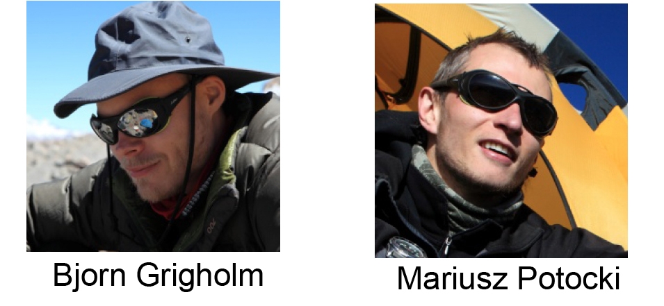
Expedition Members: Bjorn Grigholm and Mariusz Potocki
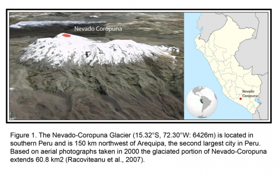
Location: Nevado-Coropuna Glacier
Dates: September 19 – October 10, 2011
Research Objectives and Scientific Goals:
In September – October 2011 a 3-week field season was conducted to the Nevado-Coropuna Glacier in Peru. The primary objective was to drill and process a ~25-30 meter ice core from the summit of the southwestern peak (6426m). Samples were to be analyzed at the Climate Change Institute for trace elements (Al, Fe, Zn, Pb, Cd, Cu, Co, Ti, Ba, Cr, Sr, V, U, Cs, Mn, As, Se, and REE suite) and water stable water isotopes (dD and d18O). The scientific goals were to establish a 50-year high-resolution, multi-parameter record, develop instrumentally calibrated climate proxies, and estimate the relative atmospheric contributions from crustal, oceanic, volcanic, and anthropogenic sources. Glaciochemical investigations from Coropuna may reveal trends and shifts in atmospheric composition and circulation patterns (e.g. variability, dust sources, Atlantic vs. Pacific advection, and El Niño Southern Oscillation (ENSO) activity). In addition, a Nevado-Coropuna ice core would span the latter 20th and early 21st century, corresponding with the rapid rises in regional industry/agricultural activities and thus has the potential to access the natural vs. anthropogenic evolution of trace elements at the site.
Previous Work and Project Rationale:
The selection of the Nevado-Coropuna as a new Climate Change Institute ice core site was based on previous Coropuna ice cores in 2003 by French and American (Ohio State University) teams (Herreros et al, 2009; Birkos, 2009). These records focused on stable water isotopes, major soluble ions, and particles and revealed that the Coropuna Glacier contained well-preserved annual signals dating back to 1760 (Vimeux et al., 2008, Birkos, 2009). Herreros et al (2009) used Ca2+ and Mg2+ as annual dust markers and developed a depth-age scale, which indicated that the 22 m depth corresponded to the years 1964-65. The annual accumulation rate was determined to be 0.39 m WE/yr (Water Equivalent/year). These findings suggest that a new 30-meter core could potentially span to the late 1950s. The presence of a well-preserved detectable annual signal makes Nevado-Coropuna an excellent site to expand glaciochemical investigations. A new record would not only provide new parameters (36 trace elements), but would also add eight years of chemistry data, allowing for improved calibrations to instrumental data. The most reliable climate reanalysis period spans from 1979-2011, thus a new Nevado-Coropuna core would extend the correlation period by one-third. It is important to note that previous research at Nevado Coropuna has not focused on calibrating glaciochemical data with instrumental records. In addition, a new core would provide the opportunity for an intra-glacial temporal and spatial glaciochemical (e.g. stable isotopes, Na, Mg, and Ca) comparison to the 2003 ice cores, evaluating ratio and concentration variability on the glacier.
Nevado-Coropuna Field Season: September – October 2011
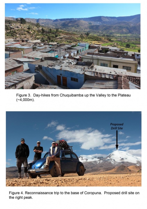
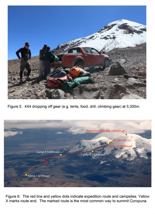
The 2011-field season began on September 20th in Arequipa (Peru’s second largest city) where we purchased the remaining field supplies (food and stove gas) and confirmed the truck rental. The following day we hired a driver to take us to Chuquibamba, a small mountain village at 3,100m. We spent three days in Chuquibamba; acclimatizing by hiking up the valley to ~4,000m and preparing our equipment (see drill image).
The Chuquibamba day-hikes were crucial in preparing us for high-altitude work. Even at the base of Coropuna, which is at an elevation of ~4,800m (15,748ft), severe altitude sickness commonly occurs. Our goal was to reach the summit (~6,400m). We would have to make several trips with heavy loads to accomplish this, thus making it additionally important to ascend at safe pace. During our stay in Chuquibamba we hired a local man to drive us to Coropuna for some reconnaissance. We wanted to check for possible trails up the mountain that a 4-wheel drive truck could traverse. The main road is at 4,800m; we hoped the truck could off-road and get our heavier gear to at least 5,300m.
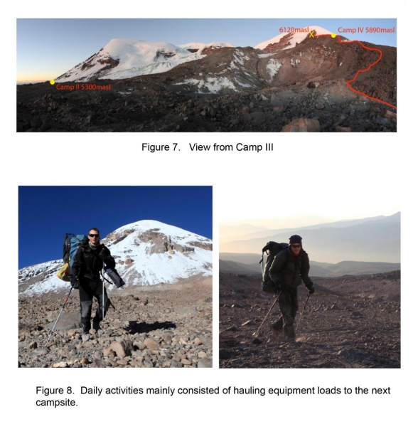
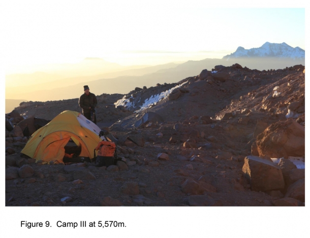
On September 27th, we packed up Camp I and moved to 5,300m and set up Camp II reuniting with our heavy gear. We spent three days at Camp II, continuing to acclimatize and hauling equipment loads to the Camp III at 5,570m. On September 30th, we moved to Camp III. The following day we began to move gear to Camp IV at 5,890m. Camp IV was our proposed final campsite before attempting the summit.
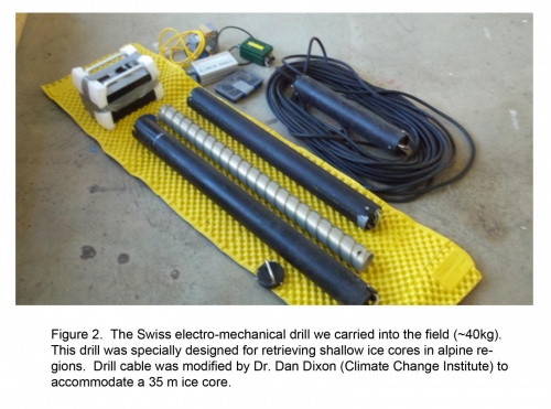
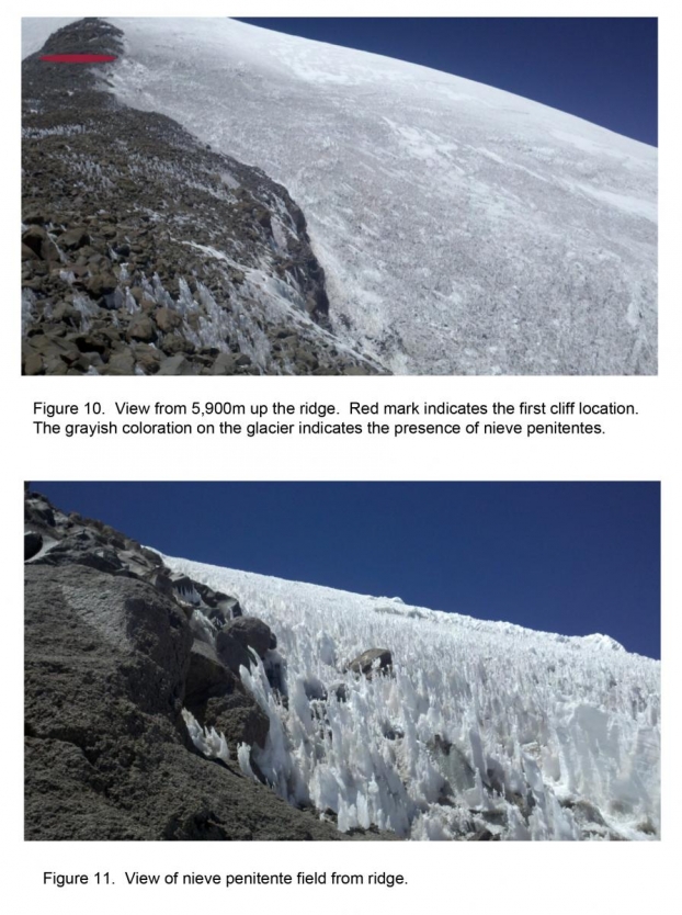
On October 4th we carried the drill up the west rib or ridge (Ridge Route) with plans to store it at the ice edge at ~6,250m. Unfortunately, at ~6,100m we reached a loose rock cliff. We removed our packs and scaled the cliff only to reach a second steeper cliff at ~6,150m. After attempting several alternative routes up the ridge we decided that climbing the rock slopes with the ice core drill (20+Kg per pack) was too dangerous. It was not only a hazard for us, but also for the drill, which would have been easily damaged if, one of us fell. Our second option was to attempt to traverse onto the glacier at ~6,100m. Unfortunately, we were forced to abandon this route by a steep crevassed ice edge and a remarkably dense field of 2-3 meter nieve penitentes (stalagmite-looking formations of hardened snow or ice that are can be present at high altitudes). These nieve penitentes make it extremely difficult to walk safely and locate crevasses. It appeared that the penitent field continued to ~6,250m.
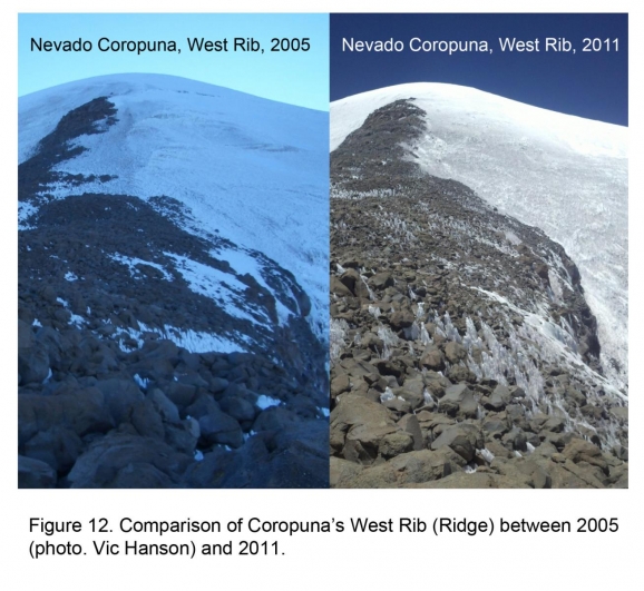
Based on climbing reports we had read and direct accounts from climbers Coropuna is routinely climbed year-round with the best time being May-November. When we reported the conditions we had experienced to local climbers they commented that this year had been unusually dry and that normally in September/October such large penitentes were not found above ~6,000m. The Ohio State University Expedition in 2003 had hiked a different route up the southwest glacier with guides and ~10 porters. Based on our observations of the OSU glacier route, ice conditions have declined significantly making the Ridge Route much more accessible, especially with only two climbers.
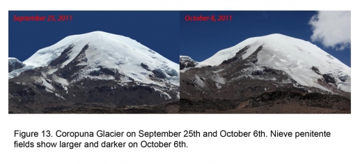
2005 conditions reveal greater ice extent onto the West Rib (ridge). We also observed significant changes in melt features (nieve penitentes) between September 25th and October 6th. With no safe route to the summit, we contacted our driver and requested to be retrieved on October 6th. We drove to a small village, just north of the mountains, to investigate the possibility of alternate routes to the summit. When we arrived, most of the villagers were away selling/buying/trading goods with other villages and only five people remained. When we inquired about alternative routes, they knew of only one, however it would require pack animals and porters, which would not be available for at least 2-3 weeks. With no safe and timely route to attempt, the only option was to return to Arequipa and end the field season.
Recent Changes in Climate
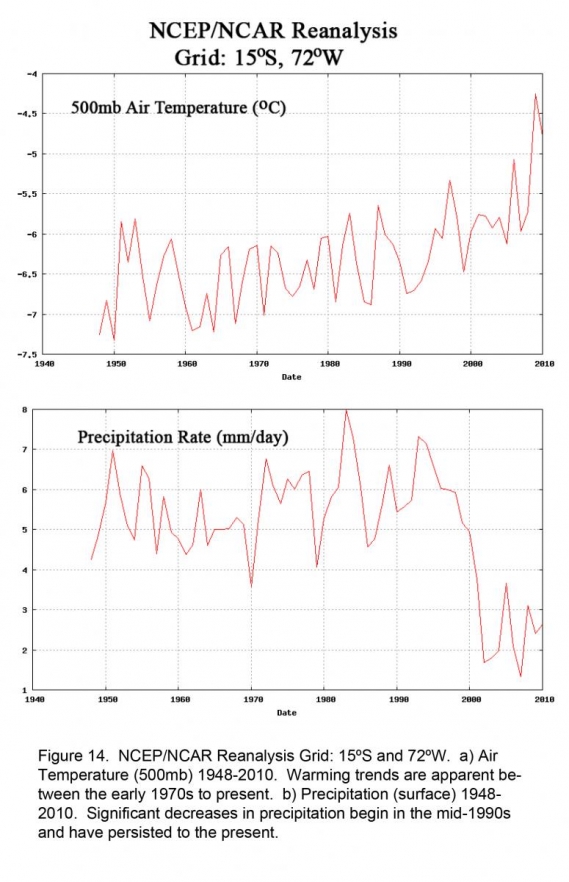
Throughout our expedition we asked locals how climate conditions had changed (e.g. temperature and precipitation). While several individuals remarked that temperatures had been steadily increasing over the last couple of decades, the dominant response was that the rainy season had decreased from 5 months (November-March) to 3 months (December-February) in the last 10-20 years. Polish Archeologist, Dr. Maciej Sobczyk (www.maa.uw.edu.pl/obp/maciejsobczyk.htm), who has been working in the region for several decades told us that 20 years ago the Coropuna glaciers were free of nieve penitentes year- round. NCEP/NCAR Reanalysis temperature and precipitation records of the Coropuna region support the anecdotal evidence showing significant changes in the last couple of decades and especially within the last ten years.
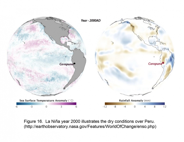
La Niña
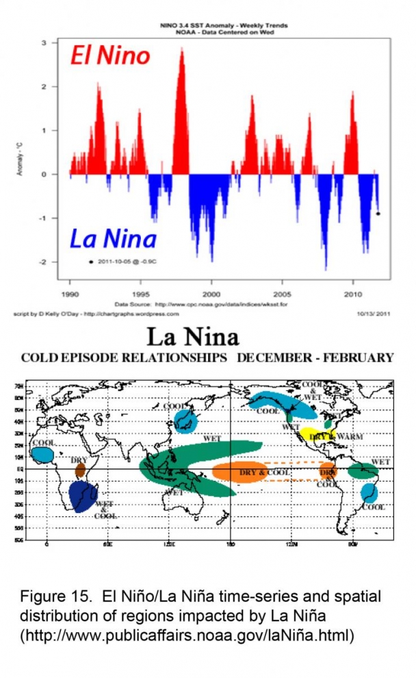
In addition to decadal temperature and precipitation trends, the El Niño-Southern Oscillation (ENSO) has tremendous impact on annual weather patterns in Peru. La Niña is a coupled ocean-atmosphere phenomenon that is essentially the opposite extreme of El Niño. El Niño is characterized by warmer ocean temperatures in the Equatorial Pacific (wetter conditions in Peru), while La Niña is characterized by unusually cold ocean temperatures (dryer conditions in Peru). These ocean temperature differences can have a profound impact on global climates. La Niña’s influence can persist for several years and in Peru generally means colder temperatures and a reduction in precipitation during the rainy season. The past and current year have been classified as La Niña years. The combination of recent warming, declines in precipitation, and a La Niña year may be responsible for the more difficult ice climbing condition this year.
Summary
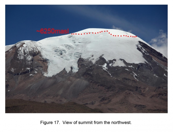
Although unable to retrieve an ice core, we were able to view snow conditions at the top of the Nevado-Corapuna Mountain. Based on our observations, the Coropuna Glacier exhibits no melt features above ~6,250m near the end of dry season. This suggests that the summit of Coropuna is still capturing and preserving snow year-round despite the recent rapid warming trend and abrupt declines in precipitation since ~2000. Well-preserved tropical ice core records are not only logistically difficult to obtain, but increasing becoming more difficult to locate as a result of anthropogenic greenhouse gas warming.
If temperature trends continue to rise over the next few years, it is possible that no portion of the Coropuna glacier will retain present-day well-preserved snow that is interpretable by ice cores. As time may be expiring for a well-preserved ice core record from Coropuna, it is important that researchers return to the site relatively soon. It will therefore, remain one of the primary ice core sites we are proposing to recover as part of a spatial array of glaciochemical records throughout the Andes. The spatial ice core array would include new ice core sites in South America as well as re-visiting former sites drilled in 1980/90s to extend glaciochemical records to the present. This proposed project would collaborate extensively with well-known South American research institutions (e.g. El Centro de Estudios Científicos (CECS), Instituto Antártico Chileno, and Centro Polar e Climático at Universidade Federal do Rio Grande do Sul).
Although Coropuna is possible to summit year-round as a light-weight climb, logistically due to the recent increases in temperatures (e.g. growing penitent fields), our future expeditions will be conducted closer to the end of the wet season in May or June, as to avoid the large (height and area) penitent fields above 6,000m. Our new contacts in Arequipa have allowed us to store a good deal of our camping and scientific equipment, which will save on future travel costs. We have also established good relations with Polish Archeologist, Dr. Maciej Sobczyk, who has 20 years of experience of working and climbing in the Nevado-Coropuna regions and would like to accompany us the next time we attempt to retrieve an ice core.
Acknowledgements:
We would like to express our deep gratitude to Dan and Betty Churchill for offering us the opportunity to plan and conduct our first independent field expedition. Although, we were not able to retrieve an ice core, the expedition has been a valuable learning experience that will help us in future endeavors. We would also like to thank Dr. Paul Mayewski for allowing us the time to conduct the expedition, offering us his knowledge/experience, and giving us his trust by lending us the ice core drill along with other vital field equipment. Thanks to Dr. Dan Dixon for modifying the ice core drill to a longer length. Finally, thanks to Kurt Rademaker and Gordon Bromley for offering advice and sharing contacts.
References
Birkos, Elizabeth. (2009). Controls on Stable Oxygen Isotope Concentrations in Coropuna and Quelccaya Peruvian Ice Cores Over the Last 200 Years. Master’s thesis, Ohio State University.
Bromley, G. R. M., B. L. Hall, K. M. Rademaker, C. E. Todd, A. E. Racoviteanu. (in press) Late Pleistocene Snowline Fluctuations at Nevado Coropuna (15ºS), Southern Peruvian Andes. Journal of Quaternary Science.
Bromley, G. R. M., B. L. Hall, J. M. Schaefer, G. Winckler, C. E. Todd, and K. M. Rademaker (2011). Glacier Fluctuations in the Southern Peruvian Andes During the Late-Glacial Period, Constrained with Cosmogenic 3He. Journal of Quaternary Science 26(1): 37-43.
Bromley GRM, Schaefer JM, Winckler G, C. E. Todd, and K. M. Rademaker (2009). Relative timing of last glacial maximum and late-glacial events in the central tropical Andes. Quaternary Science Reviews 28: 2514–2526.
Herreros, J., Moreno, I., Taupin, J. D., Ginot, P., Patris, N., De Angelis, M., Ledru, M. P., Delachaux, F., and Schotterer, U.: (2009). Environmental records from temperate glacier ice on Nevado Coropuna, Southern Peru. Adv. Geosci., 22, 27–34.
Racoviteanu, A. E., Manley, W. F., Arnaud, Y. & Williams, M. W. (2007). Evaluating digital elevation models for glaciologic applications : an example from Nevado Coropuna, Peruvian Andes. Global and Planetary Change, doi :10.1016/j.gloplacha.2006.11.036.
Vimeux, F., Ginot, P., Schwikowski, M., Vuille, M., Hoffmann, G., Thompson, L. G., and Schotterer, U. (2008). Climate variability during the last 1000 years inferred from Andean ice cores: A review of methodology and recent results, 2008 Palaeogeogr. Palaeocl, doi:10.1016/j.palaeo.2008.03.054.