
Ice Core Reconnaissance and Ice Volume Survey in the Alaska Range/Denali National Park and Preserve, Alaska
Ice Core Reconnaissance and Ice Volume Survey in the Alaska Range/Denali National Park and Preserve, Alaska
2012 Field Team Members: Seth Campbell, Curtis Marston, Lyndsey Marston, Josh Plourde (University of Maine); Kristin Schild (Dartmouth College); Brad Markle (University of Washington); Dave Silverstone (University of Alaska); Adam Toolanen (Lund University, Sweden)
Location of Field Expedition: Denali National Park and Preserve, Alaska
Dates of 2012 Expedition: April 16, 2012 – May 31, 2012
Blog Entry – April 16, 2012
Editor’s Note: This is a series of blog posts from UMaine’s Climate Change Institute which is currently conducting fieldwork in the Alaska Range. Seth Campbell, a University of Maine graduate student pursuing his Ph.D. through UMaine’s Climate Change Institute and Department of Earth Sciences, is getting ready to lead an expedition in Denali National Park in Alaska. This will be his fifth field season in Denali.
http://adventures-in-climate-change.com/editorsdesk/index.php/2012/04/16/measuring-the-amount-of-ice-in-the-alaska-range/
I am in Alaska already working on a couple of different projects I’m involved with before I go into the field for the Denali project on April 21. We have quite a team this year to help in the field research including myself; UMaine undergraduate Josh Plourde; former UMaine students Curtis Marston and Lyndsay Marston; Kristin Schild, who earned her master’s degree at UMaine’s Climate Change Institute and is now working on a Ph.D. in earth sciences at Dartmouth; Brad Markle: A Ph.D. student in glaciology student at the University of Washington; Dave Silverstone, an undergraduate student at the University of Alaska Anchorage; Adam Toolanen, an undergraduate student at Lund University in Sweden; and Hazel Shapiro, an undergraduate student at Dartmouth.
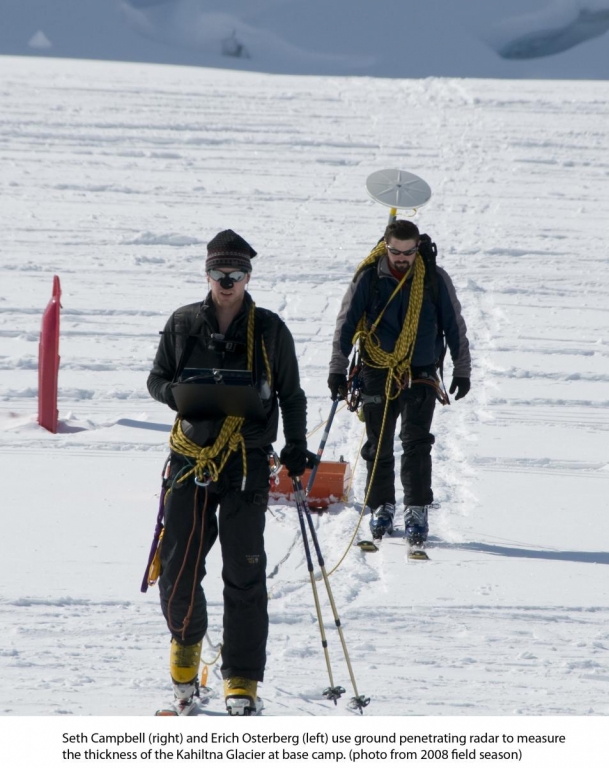
The most exciting news recently is that the proposal submitted to the National Science Foundation by Dr. Erich Osterberg (Dartmouth), Dr. Karl Kreutz (UMaine), and Dr. Cameron Wake (University of New Hampshire) was funded to start ice core drilling on Mount Hunter, Alaska, beginning in the spring-summer of 2013. This proposal is many years in the making for Karl, Cameron and Erich, including the past four years with dozens of people helping either in the field or processing samples and data back at UMaine, Dartmouth, or UNH. Although the drilling doesn’t start until 2013, we still need to download meteorological data from a station we installed on the Kahiltna Glacier in 2008. The station records such details as hourly temperature, humidity and precipitation, which are useful for comparison to the ice core once we actually extract it for chemical analyses.
Beyond the recently funded NSF proposal and downloading the meteorological data, this year’s field team is helping me with a different task of estimating total ice volume in the Alaska Range. We will be using ice-penetrating radar to measure ice depths on the Traleika, Muldrow, Kahiltna, and Ruth glaciers between April 21 and May 31. This ice depth data from a select few glaciers will be used to test or improve a numerical calculation that relates ice depth to glacier surface area, a method known as area-volume scaling. We hope to use this mathematical relationship developed from a few glaciers to calculate the total ice volume retained in the dozens of glaciers situated in the Alaska Range.
To collect the ice depth data we tow an ice-penetrating radar system behind us while we ski on each glacier. We ski from remote camp to remote camp, setting up tents at the end of each day. The complete radar system that we use includes an antenna transmitter that sends electromagnetic (EM) pulses through the ice and an antenna receiver that receives the reflection of each EM pulse from layers in the ice and bedrock under the ice. The antenna is connected by cable to a computer which records data about each EM pulse sent and received by the transmitter-receiver combination. We know how fast radio waves travel through ice. Therefore, we can calculate how deep the ice at each location we measure if we record the time it takes for each radio wave pulse to return to the receiver after it is transmitted. The collection process required a team effort. We towed the antenna behind us while skiing at rates between 1-2 kilometers per hour (basically a slow walk). We travel slowly to improve the contact between the ice and the antenna which assures that the radar signal is sent into the ice. It is also hard work to tow the radar system!
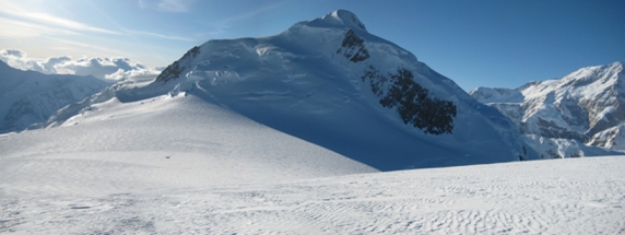
The work can be exhausting and challenging physically (and emotionally on some days), and the day doesn’t end after the daily field science work is completed. At the end of the day we spend several hours setting up tents, melting snow for water, cooking food, charging batteries with solar power equipment and preparing for the next day. That said, we are lucky enough to work in one of the most amazing mountain ranges in the world. With mountains more than two miles high towering above us, the scenery can’t be beat.
We have divided this season into three mini-seasons because our team members are staggering their visits to the glacier. Between April 21-29, Curtis, Lyndsey and I will be collecting ice depth data on the Traleika and Muldrow Glaciers. Between April 29 and May 15 we will collect data on the Kahiltna Glacier with new team members Dave, Adam and Brad. On May 15 our final field team shows up and some team members depart. We will then either finish field activities on the Kahiltna Glacier or fly to the Ruth Glacier for two more weeks of ice data collection before we end the season.
Blog Entry – May 7, 2012
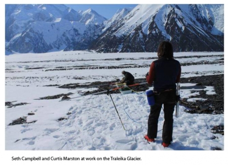
We just returned from our short field season on the Traleika and Muldrow Glaciers, where we collected ice depth data and measured glacier velocity at locations that Denali National Park and Preserve scientists have maintained during the past several years.
We were picked up by the park helicopter around 3:30 p.m. today (May 2) and transported back to Kahiltna Base Camp where we are staging our next two weeks of field work primarily on the Kahiltna Glacier. Curtis, Lyndsey and I met three of our other field researchers (Brad Markle, Adam Toolanen and Dave Silverstone) at base camp today and we plan to depart up-glacier tomorrow morning. During the next three days, we will place stakes in the glacier between 7,400 and 10,000 feet above sea level and measure the location of each stake with a GPS system. We will re-measure the stake locations at the end of the field season to determine ice flow velocities at each stake site. We will also collect some images of the internal structure and depth of ice on the upper Kahiltna Glacier using ground-penetrating radar (GPR), so that we can estimate the amount of ice flowing past a given point per unit time (called ice volume flux).
As far as weather, two days of snow and one day of poor visibility and cloudy conditions on the north side of the mountain (Muldrow and Traleika glaciers) certainly slowed our work down and we spent much time tent-bound waiting out the 16 inches of fresh snow. Once the snow cleared we had minus 20 or colder temperatures to contend with last night into this morning. As I write this today, I think we are dropping down to minus 20 again tonight. At these temperatures, field work becomes much slower during the day and we usually wait until the sun is fully in the sky to take advantage of any warmth we can. I currently have several batteries in my sleeping bag to keep them warm. When we travel and just prior to collecting data, I usually have any cables that work as part of the radar system within my jacket to keep them warm and flexible. The cold makes every delicate piece of equipment all the more breakable, so slow and deliberate use of the equipment and little tricks with the equipment (such as hand warmers on the batteries of the radar system during operation) can make all the difference between collecting field data and coming home empty-handed.
The north side of the mountain also has a very different character than the south side. The north sits in the snow/rain shadow, so the region is much drier than the south-facing Alaska Range. Besides the drier conditions, wildlife seemed a bit more abundant considering the Muldrow sits on the edge of the Arctic tundra. We heard a group of wolves howling on the ridge off to the north of the Muldrow one night; we followed tracks of what may have been a marten on another; and had several species of birds (which are also common on the south side of Denali) fly past us and visit camp for a quick stop within the tent vestibule to warm up from the cold before moving on.
We are all in good spirits. A good round of mixed-berry pancakes and bacon for dinner (we know, usually a breakfast item!) with some hot Gatorade closed out the evening. The sleeping bags are all full of hot water bottles to keep us warm through the night. We were able to charge some batteries up with the solar power systems this evening. We all hope for sunny and a bit warmer weather tomorrow as we start to move up glacier for the second round of our research this season. More to come in a few days!
****
In 2008 a team led by Dr. Karl Kreutz (University of Maine), Dr. Erich Osterberg (graduate of Maine and now assistant professor at Dartmouth College), and Dr. Cameron Wake (University of New Hampshire) lead a collaborative effort to locate a potential ice core drill site in the Alaska Range, appropriate for extracting a Holocene length ice core useful for paleoclimate studies. Since 2008, participation in this evolving collaborative project through two Denali National Park Research permits has included over 17 students and six faculty from eight university institutions and two federal agencies.
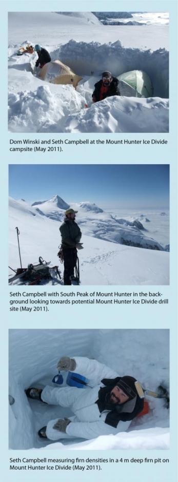
This research was continued and expanded in 2009 through 2011 under continued support from the National Science Foundation, American Alpine Club, Dan and Betty Churchill Exploration Fund, the University of Maine graduate school government, Denali National Park and Preserve, and the US Army Cold Regions Research and Engineering Laboratory. A potential ice core site has since been located on an ice divide situated between the North and South Peaks of Mount Hunter within Denali National Park and Preserve, and we estimate upwards of 4000 years of ice exist at this location, making it potentially one of the longest high resolution climate records available within continental Alaska. We have utilized the following techniques to characterize the potential ice core drill site:
- Radio-glaciology for measuring ice depths and relative deformation recorded within glacier stratigraphy (led by Seth Campbell).
- High precision GPS measurements to determine surface ice flow velocities and strain rates and surface topography (led by Seth Campbell).
- Firn pit and shallow firn core samples for trace metal, ion, and isotope analyses, to determine accumulation rates and chemical variability, as well as radioactive properties resulting from the recent Japanese nuclear accident (Led by Dr. Karl Kreutz and Dr. Erich Osterberg).
- Steady state and transient finite element numerical modeling of the ice divide using field data as model boundary conditions, useful for estimating potential deformation when an ice core is eventually extracted from the site. (Led by Samuel Roy and Seth Campbell).
- Energy Balance and mass balance studies utilizing field data and local meteorological station data (led by Dom Winski).
Beyond the initial ice core reconnaissance efforts, we have expanded research efforts in Denali National Park and the Alaska Range. An expedition planned for April-May, 2012 includes the following planned research:
- Development of ice depth and total ice volume estimates within the Alaska Range using radio-glaciology and area-volume scaling methods on the Traleika, Muldrow, Kahiltna, and Ruth Glaciers (led by Seth Campbell).
- Repeat field surface ice flow velocity measurements on the Kahiltna Glacier (led by Seth Campbell).
- Download Meteorological (MET) station data from a station installed in 2008 and collect snow pit samples on the Kahiltna Glacier for short term seasonal chemistry (e.g. isotope, ion, trace metals) comparison to the MET data (led by Dr. Karl Kreutz and Dr. Erich Osterberg).
- Analysis of radioactive tracers from the Japanese Nuclear disaster (led by Dr. Erich Osterberg).
- Incorporation of all related glaciological and climate change research from this 5 year project into new interactive outreach programs for the iOS Apple Platform (led by Dr. Karl Kreutz and Josh Plourde).
Related Publications:
Campbell, S., Kreutz, K., Wake, C., Osterberg, E., Arcone, S., Introne, D., Winski, D., Volkening, K. 2012. Melt regimes, internal stratigraphy, flow dynamics, and glaciochemistry of three glaciers in the Alaska Range. J. Glaciol. 58(207). 99-109. doi:10.3189/2012JoG10J238
Campbell, S., Kreutz, K., Wake, C., Osterberg, E., Arcone, S., Winski, D., Volkening, K. 2012. Flow dynamics of an accumulation basin: A case study of the upper Kahiltna Glacier on Mount McKinley, Alaska. J. Glaciol. 58(207). 185-195. doi: 10.3189/2012JoG10J233
Campbell, S. 2011. Learning about climate change from ice cores. Denali National Park Public Fact Sheet. http://www.nps.gov/dena/naturescience/upload/Ice-Core-2011-Wake-Campbell.pdf
Kelsey, E., Wake, C., Kreutz, K., Osterberg, E. 2010. Ice layers as an indicator of summer warmth and atmospheric blocking in Alaska. J. Glaciol. 56(198). 715-722.
Winski, D., Kreutz, K., Osterberg, E., Campbell, S., Wake, C., Arcone, S., Kelsey, E., Volkening, K., Hawley, R. 2011. Effects of melt on snowpack stratigraphy and chemistry on the Kahiltna Glacier, Alaska. Submitted. Hydrological Processes.
Winski, D., Kreutz, K., Osterberg, E., Campbell, S., Koons, P., Hooke, R., Birkel, S. Modeling surface energy balance on the Kahiltna Glacier, Alaska. Submitted. Journal of Geophysical Research.
Prior Field Expeditions and Field Participants for same project:
May, 2008
Karl Kreutz (University of Maine;-Co-PI); Cameron Wake (University of New Hampshire; Co-PI); Erich Osterberg (Dartmouth Colle; Co-PI; Seth Campbell (University of Maine); Ben Gross (University of Maine); Eric Kelsey (U New Hampshire; Mike Waskiewicz (DataNorth); Ron Lisnet (University of Maine)
May, 2009
Erich Osterberg (Dartmouth College ); Seth Campbell (University of Maine); Max Lurie (University of Maine); Tom Callahan (Dartmouth College); Kevin Volkening (Montana State)
May, 2010
Karl Kreutz (University of Maine); Seth Campbell (University of Maine); Dom Winski (University of Maine); Noah Kreutz (Asa Adams Middle School); Kevin Volkening (Montana State); Loren Rausch (Montana State); Austin Johnson (Past UMaine Earth Sciences B.S. graduate; currently at University of Alaska Geophysical Institute)
May-June, 2011:
Seth Campbell (University of Maine); Dom Winski (University of Maine); John Thompson (Dartmouth College)