
Archaeological Explorations in the Chao Valley, North Coast of Peru
Chao Valley, North Coast of Peru
Archaeological Explorations in the Chao Valley, North Coast of Peru
Participant: Ana Cecilia Mauricio
Location: Chao Valley, North Coast of Peru
Date: July 2011
Introduction
Archaeological explorations are a critical part of archaeological research. Recognition of the cultural and environmental characteristics of the area to be studied is the basis for any investigation that intends to analyze human behavior in the past. Archaeological settlements were not isolated spaces; all kinds of remains that are found inside these places (including architecture, design, location, etc.), reflect aspects of the natural and cultural environment of a particular space and time. Particularly, archaeological research that attempts to assess ancient human-environment interactions should employ a regional scale to understand characteristics and transformations of the local environment.
The Chao Valley
The Chao Valley is a relatively small and narrow coastal valley, located on the north coast of Peru, on the western flank of the Andean Cordillera. Its annual mean temperature is 16 °C and its annual mean precipitation varies from 7 mm minimum to 40 mm maximum. To date most of the lands in the lower valley are under industrial cultivation by Peruvian and international companies using waters of the Chavimochic irrigation project (brought from the Santa Valley, located to the south of Chao), which provides water for agriculture to the Chao, Virú, and Moche Valleys. The Chao river basin has a longitude of approximately 76 km long
Previous work
Several archaeological sites have been reported in Chao which cover thousands of years of Peruvian prehistory, starting around 5000 years ago. Nevertheless, despite the high number of archaeological settlements, there have been few archaeological investigations that have focused on this valley.
In the 1970’s, as part of an archaeological project that tried to established the chronology of the use of maritime resources in Peruvian prehistory, Mercedes Cárdenas (1977) and other archaeologists recorded 187 archaeological sites in the lower Chao valley. The earliest sites were associated with the Middle and Late Preceramic Period (ca. 8000 B.P to 4000 B.P.).
In the 1980’s and 1990’s an intensive rescue survey was carried out in the lower Chao Valley when a major irrigation project (Chavimochic) was about to build irrigation canals in the lower and middle valley. In this opportunity 139 sites were located mainly in the upper part of the lower valley and in the middle valley (Carcelén at al. 1999). Many of these sites had already been recognized by Cárdenas and her team (e.g., Alva 1986) some years ago.
Apart from these two major projects, there have been no other surveys focused specifically on the Chao Valley. Moreover, it is remarkable that none of these projects have centered their attention on the study of the prehistoric settlement pattern of this Valley.
Summer Exploration 2011
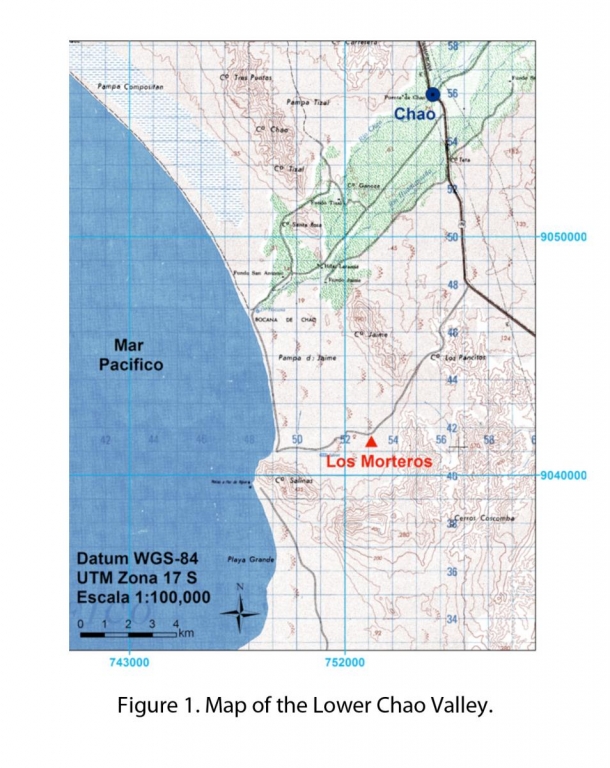
Last July 2011 I undertook an archaeological exploration in the lower and middle Chao Valley (Figure 1) with the main objective of recognizing the kinds of archeological sites present, their location, extension, and age. I started in the upper zones and worked down to the lower valley. In addition to this, my intention was to assess the current condition of the sites that were previously recognized, to evaluate natural erosion, partial or total destruction by agricultural and other constructive activities, and looting. Another important goal was to familiarize myself with the local and regional natural setting of the Chao Valley.
During two weeks a total of 62 sites were visited, other sites were either now located inside private property (which made them impossible to visit), or were not located at all, maybe because they were destroyed or had wrong coordinates. My impression from this work is that ~30% of the sites located in prior studies are now destroyed, which makes further research in the Chao Valley even more urgent.
Results
A total of 62 were visited during this exploration. The earliest seem to correspond to the Preceramic Period; however, it was not possible to assign them to a specific Preceramic phase due to the lack of diagnostic elements. Nevertheless, some of these sites were dated previously by Cárdenas et al. (1977-78) and were associated to the Middle and Late Preceramic Periods.
The latest sites had Chimú ceramics spread over their surface, indicating that they were occupied during the Late Intermediate Period around 1400 A.D. Some of sites that illustrate the prehistoric human occupation in this valley are:
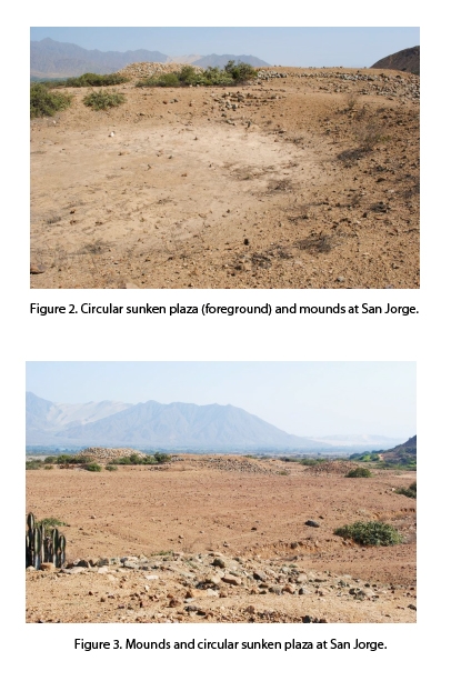
San Jorge (Figures 2 and 3)
This site was located in the middle valley, close to the route that goes to the Districts of Chorobal and Palmabal. This site is located on an alluvial terrace, where the Chao River becomes narrow and the Valley becomes a canyon. The UTM coordinates for this site are 771064E 9064656S, zone 17L. This site seems to have been recorded under the name of San Carlos, however the coordinates assigned to this site in the INC catalogue (Carcelén et al. 1999) do not match with my UTM coordinates. San Jorge is a big site composed of up to 12 small artificial mounds (probably truncated pyramids), that are enclosed by a stone wall that extends from the edge of the terrace (southeast) to the mountains (northwest). A particular characteristic of this site is the circular sunken plaza that is located to the east side of the biggest mound. The mounds were made of boulders and mud. There were only few sherds on the surface, none of them were diagnostic, and they seem to be related to a later use of the site. In general, San Jorge seems to be one of the oldest sites in Chao, probable from the Late Preceramic or the Initial Period (5800 B.P to 900 B.P. [Before Present]).
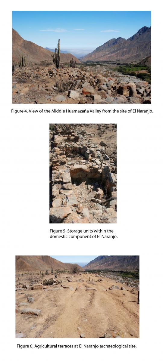
El Naranjo (Figures 4, 5, and 6)
This site is located in the middle valley of the Huamanzaña River which is a tributary of the Chao River. Its UTM coordinates are 782925E, 9060872S, zone 17L. El Naranjo is a large site that is also located on an alluvial terrace. This part of the valley is very narrow and the narrow terraces are the only parts appropriated for cultivation, which seems to have been the purpose of this site. El Naranjo occupies a large extension of a terrace located on the south flank of the river. This site is composed of a series of agricultural terraces on the west part of the site, to the east there are stone rooms, patios, and storage units that seem to be grouped. The most eastern part of the site has big spaces enclosed by stone walls but their architecture is irregular and not as well organized as the rest of the site; it seems that these structures were used as corrals for llamas or other animals. Judging from the kind of architecture, El Naranjo seems to be a Middle Horizon Period site (ca. 700 A.D to 900 A.D.).
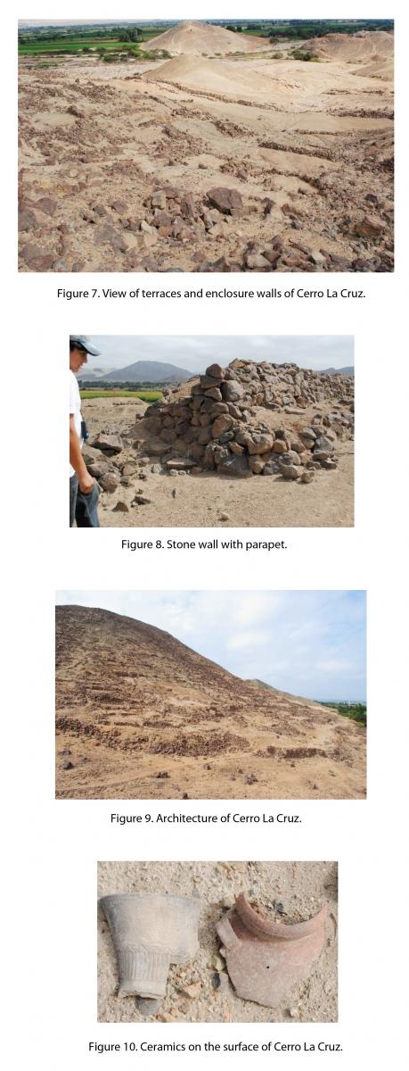
Cerro La Cruz (Figures 7, 8, 9, and 10)
This is a big settlement located on hill called Cerro La Cruz (760135E 9062602S, zone 17L), lower Chao Valley, very close to the District of Bella Vista. It was the focus of Melissa Vogel’s dissertation work and recent book (Vogel 2011). This settlement covers almost all hill surfaces, from the top to the bottom. Cerro La Cruz has terraces over which tens or hundreds of rooms were built. Two big mud brick structures are located to the north and south flanks. Three concentric stone walls enclose Cerro La Cruz; in some parts these walls are 1.5 m height, the most internal walls have parapets and are wide enough to walk over them. There are abundant ceramic fragments on the surface of the site. These fragments show that the site was occupied since at least the Early Intermediate Period (200 A.D. to 550 A.D.) to the Late Intermediate Period (1150 A.D. to 1450 A.D.). The kind of architecture of Cerro La Cruz seems to indicate a defensive function of the site, although it is not clear when in the long occupation period of Cerro La Cruz those walls were built.
Conclusion
The Chao Valley has evidence of prehistoric human occupation for thousands of years and covers almost all periods of Peruvian prehistory. Nevertheless, it is the earliest occupation of the Valley that seems to be hardest to securely identify because of the lack of ceramics and other more diagnostic elements.
On the other hand, although it was not possible to have access to all sites recorded or mentioned in previous works because a number of them are now inside private property, it is very obvious that since the last archaeological survey of 1990’s many sites have disappeared. In some cases it is still possible to recognize parts of ancient structures, in other cases the destruction is total, and in many cases the destruction is an ongoing issue.
Acknowledgement
I am very grateful for the generous support from the Dan and Betty Churchill Expedition Fund, Marshall Cloyd, and The Graduate Student Government.
References
Alva, Walter (1986). Las Salinas de Chao. Materialien zur Allgemeinen und Verglieichenden Archäologie, Band 34. C.H. Beck, Munchen.
Cárdenas, Mercedes (1977-78). Obtención de una Cronología para el uso de Recursos Marinos en el Antiguo Perú. Boletín del Seminario de Arqueología 19-20. Lima.
Carcelén, José and Orlando Angulo (1999). Catastro de los sitios arqueológicos del área de influencia del canal de irrigación Chavimochi. Valle Viejo de Chao. Instituto Nacional de Cultura-La Libertad, Trujillo.
Oficina Nacional de Evaluación de Recursos Naturales (ONERN) (1973). Inventario, evaluación y uso racional de los recursos naturales de la costa. Cuencas de los Ríos Virú y Chao. Vol I and II. República del Perú, Presidencia de la República, Lima.
Vogel, Melissa (2011). Frontier Life in Ancient Peru. The Archaeology of Cerro la Cruz. University of Florida Press, Gainseville.