
Melt Pond Evolution and Glacier Acceleration: Fast Glacial Flow in East Greenland
Melt Pond Evolution and Glacier Acceleration: Fast Glacial Flow in East Greenland
This Project is supported in part by a generous grant from the Dan and Betty Churchill Exploration Fund
Gordon Hamilton and Leigh Stearns
June 22, 2006 to August 29 2006
Mass from the interior of the Greenland ice sheet is transported to the ocean by numerous large, fast flowing outlet glaciers. Changes in the flow configuration of these outlet glaciers modulate ice sheet mass balance and sea level. Recent estimates show that Greenland’s contribution to sea level has more than doubled in the past decade.
Our project is a partnership with colleagues from Harvard University, Lamont-Doherty Earth Observatory (LDEO), the Danish National Space Center (DNSC), the Geological Survey of Denmark and Greenland (GEUS), and the Consejo Superior de Investigaciones Cientificas, Spain (CSIC) (see Helheim 2006 for details). The objective of the larger project is to characterize the behavior of glacial earthquakes beneath fast moving outlet glaciers in Greenland (Ekström et al., 2006). The seasonality and distribution of these earthquakes implies a correlation with subglacial hydrology. We hypothesize that the subglacial drainage system, which must adjust for an increases in melt water due to warming, causes glacier acceleration and small seismic events.
Our project will be to deploy five GPS stations down-stream of a large melt pond. If time permits, we will place a sixth GPS unit up-stream of the melt pond, as a control. An automatic weather station (AWS site) will be installed on an adjacent mountain ridge. Given any flexibility in the logistics, we will position two AWS sites at two different elevations, to quantify the effect of elevation on weather observations (lapse rate).
Leigh Stearns
Introduction
Mass from the interior of the Greenland ice sheet is transported to the ocean by numerous large, fastflowing outlet glaciers. Changes in the flow configuration of these outlet glaciers modulate ice sheet mass balance and sea level. Recent estimates show that Greenland’s contribution to sea level has more than doubled in the past decade, increasing from 0.23 � 0.08 mm/yr in 1996, to 0.57 � mm/yr in 2005, and that the majority of this mass loss is due to changes in the flow configuration of a few large outlet glaciers (Rignot and Kanagaratnam, 2006). Three glaciers in particular (Kangerdlugssuaq Glacier, Helheim Glacier, and Jakobshavn Isbr�), have undergone dramatic acceleration, retreat and thinning in the past 5 years (Stearns and Hamilton, 2005).

Figure 1: Location of the fast moving outlet glaciers discussed in this proposal.
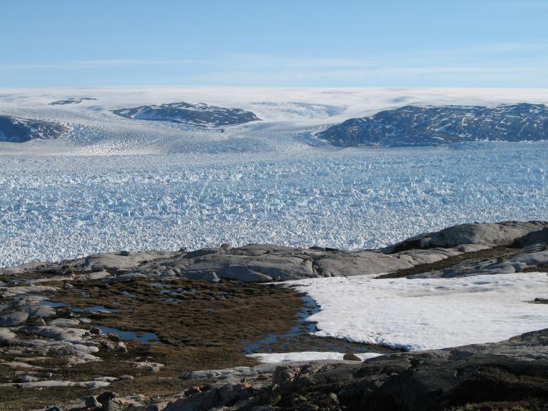
Between 2001 and 2005, Kangerdlugssuaq Glacier, Helheim Glacier, and Jakobshavn Isbr� (Figure 1) each accelerated 30-300%, retreated >5 km, and thinned >100 meters. There is compelling evidence that these sudden changes were triggered by warm summer temperatures. On Kangerdlugssuaq and Helheim glaciers, the initial acceleration coincided with an especially warm summer and a modeled increase in melting degree days (based on measurements from the nearest available weather station). The warmer summer temperatures cause an increase in melt ponds on the glacier surface. We hypothesize that enhanced lubrication caused by an increase in surface meltwater reaching the bed caused flow acceleration. In support of this hypothesis, flow velocities derived from repeat satellite imagery show velocity “bullseyes” located directly down-flow of large melt ponds. Acceleration from surface melt percolating to the bed and causing lubrication has been observed on the inland ice sheet in west Greenland (the so-called ‘Zwally effect’) (Zwally et al., 2002).
Research Objectives
The Arctic plays a prominent role in global climate change research because of both its sensitivity to changing climate and because of the relative wealth of paleoenvironmental proxy records available. Proxy records developed through physical and chemical analyses of ice cores provide the highest resolution and most direct view of Earth’s paleoatmosphere over time scales ranging from single seasons to hundreds of thousands of years. Recent research efforts have focused on developing high resolution ice core records from the St. Elias Mountains in southwestern Yukon Territory and southeastern Alaska (Fig 1). During the summers of 2001 and 2002, scientists from the Geological Survey of Canada (GSC), National Institute for Polar Research in Tokyo, University of New Hampshire (UNH), and University of Maine (UMaine) recovered ice cores from three different glaciers in the St. Elias Mountains, southwestern Yukon Territory. On the Eclipse Icefield (~30 km northeast of the Logan Massif) an UNH/UMaine team recovered a 345 m core along with three other shallower cores.
- How sensitive is ice velocity to fluctuations in melt pond volume?
- How do melt ponds and water filled crevasses evolve throughout the season? How does their volume fluctuate throughout the summer months?
- How does ice velocity change through an entire summer season? Does it increase throughout the season or does it remain relatively constant? Is the ice moving steadily, or is the motion taken up in several short bursts of movement?
- What is the local air temperature and weather characteristics at different elevations along the glacier (current degree day models rely on weather observations 80 km, and 1000 vertical meters away)?
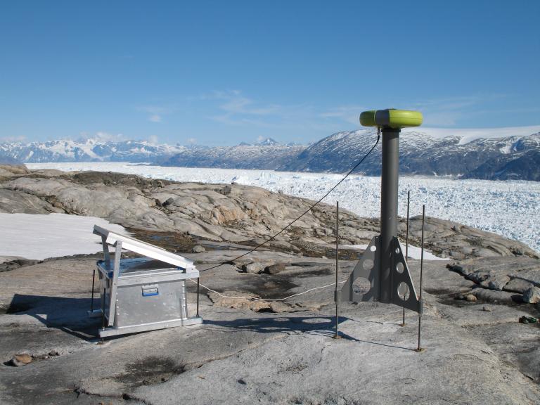
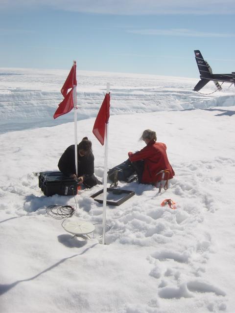
There are three components to our proposed field program: determine ice velocity variations with global positioning system (GPS) measurements; monitor melt water production by placing a pressure transducer in a large melt pond; and record the local weather with at least one automatic weather station (AWS). We plan on deploying all the equipment on the glacier for the entire summer season (June – September, 2006), with data being recorded (on average) every minute.

Figure 2. Proposed setup of field equipment. Five GPS stations will be deployed down-stream of a large melt pond. If time permits, we will place a sixth GPS unit up-stream of the melt pond, as a control. An automatic weather station (AWS site) will be installed on an adjacent mountain ridge. Given any flexibility in the logistics, we will position two AWS sites at two different elevations, to quantify the effect of elevation on weather observations (lapse rate).
Our project evolved as a partnership with colleagues from Harvard University, Lamont-Doherty Earth Observatory (LDEO), the Danish National Space Center (DNSC), the Geological Survey of Denmark and Greenland (GEUS), and the Consejo Superior de Investigaciones Cientificas, Spain (CSIC). The objective of the larger project is to characterize the behavior of glacial earthquakes beneath fast moving outlet glaciers in Greenland (Ekstr�m et al., 2006). The seasonality and distribution of these earthquakes implies a correlation with subglacial hydrology. We hypothesize that the subglacial drainage system, which must adjust for an increases in melt water due to warming, causes glacier acceleration and small seismic events.
Fieldwork Details and Logistics
I am requesting support from the Churchill Foundation for 14-days of lodging at Hotel Angmagssalik ($70/day). The hotel is located in the southeast Greenland town of Tasiilaq, roughly 80 km from our field site. The remaining cost of the project will be covered by Dr. Hamilton and our project partners. Funds requested here will support my involvement in investigating meltpond evolution and ice velocity (a project which was not planned otherwise).
Journal Entries
June 22, 2006 to July 6, 2006

The main goal of our Helheim 2006 project is to understand the mechanisms bywhich glacial �ice�quakesoccur, and their relation to glaciological processes. Information about the projectlogistics and team members can be found at Lamont-Doherty Earth Observatory, Columbia Universityand our own Project Page. Basically, we are setting up a network of GPS stations acrossthe glacier to determine ice flow patterns in relation to ice quake events (andbecause ice flow patterns are interesting and glaciologically relevant). Icequakes (also called glacial earthquakes) have been recorded around Helheim glacierduring the summer season for the past XX years. In order to try to �capture� oneof these events in the GPS data, we are aiming to leave the receivers on the ice for ~2-3 months this summer.
Three field trips are organized for the summer 2006 season. The first trip (June 24 � July 2) is the deployment phase, where we put all 20 (hopefully) GPS receivers on the surface of Helheim Glacier. Because this is a fast moving glacier (~11 km/yr at the calving front), and the GPS receivers are expensive, a mid-campaign trip is planned for July 21- July 27 to download available data and insure the stability of the equipment. It is possible that the receivers will no longer be in a �safe� location and we will have to pull them out before they fall in a crevasse. The third trip is scheduled for late August and is when we will pull out all of the instruments. We hope to do this BEFORE any snow falls so that crevasses are easy to see.
TRIP 1: GPS deployment June 27, 2006 Tasiilaq, Greenland
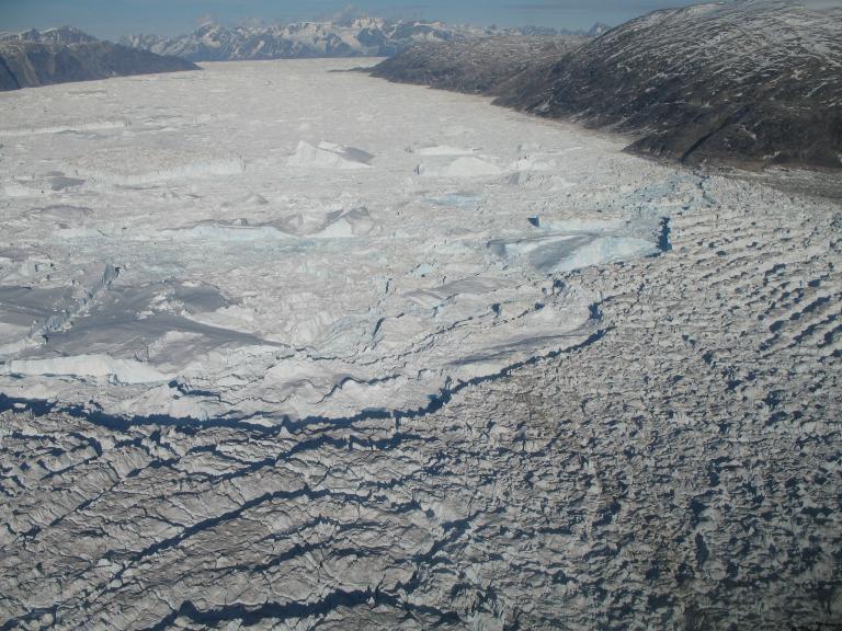
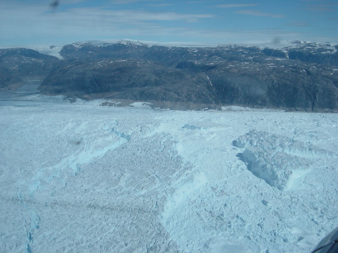
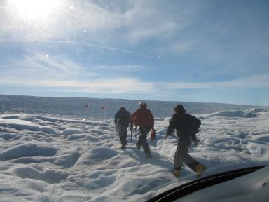
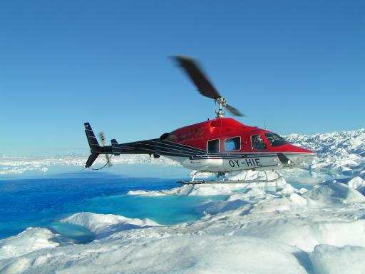
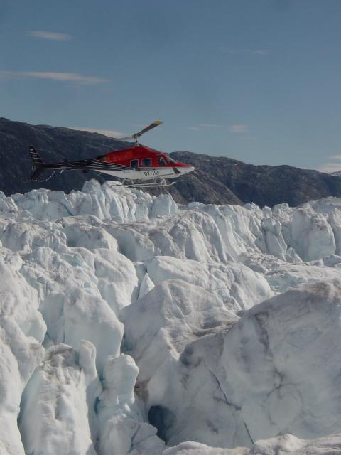
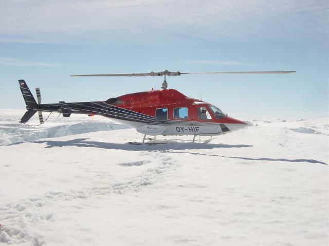
We are spending the week at Tasiilaq, which is the closest village to Helheim Glacier. We have chartered a Bell 222 helicopter to transport us (and our gear) to and from the glacier, ~100 km to the northwest. Unfortunately helicopter time is REALLY expensive, so we have to be organized in our planning and efficient in our site installation. However, Helheim Glacier is extremely crevasses (see pictures) and is therefore very hard to land a large helicopter on. A good portion of our time is spent searching for safe places to land and checking to make sure that the ice is sturdy to walk on.
Gordon, Andreas Ahlstrom (from GEUS) and I headed to Helheim Glacier this afternoon to deploy two GPS stations at the snout (or front) of the glacier, while colleagues from the Danish National Space Center (Abbas Khan and Lars Stenseng) set up a base station on an adjacent nunatak. Our plan is to leave two receivers at the front of the glacier for 2-4 days, to get a sense of the glacier velocity and any influence the tide may have on the ice motion. Since we left the equipment so close to the calving front (where the glacier calves off icebergs into the fjord), it is important that we retrieve the GPS receivers within a few days or they will most certainly fall into the fjord! The installation was successful and the glacier, as always, was stunning.
June 28, 2006 Tasiilaq, Greenland
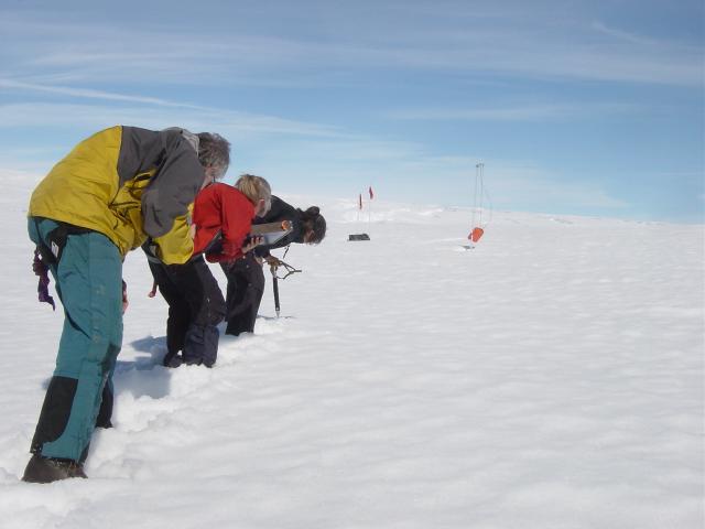
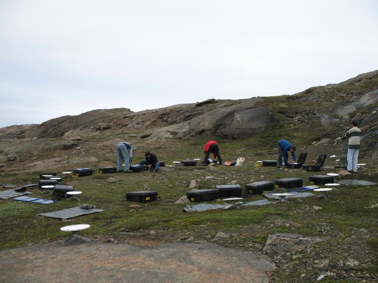
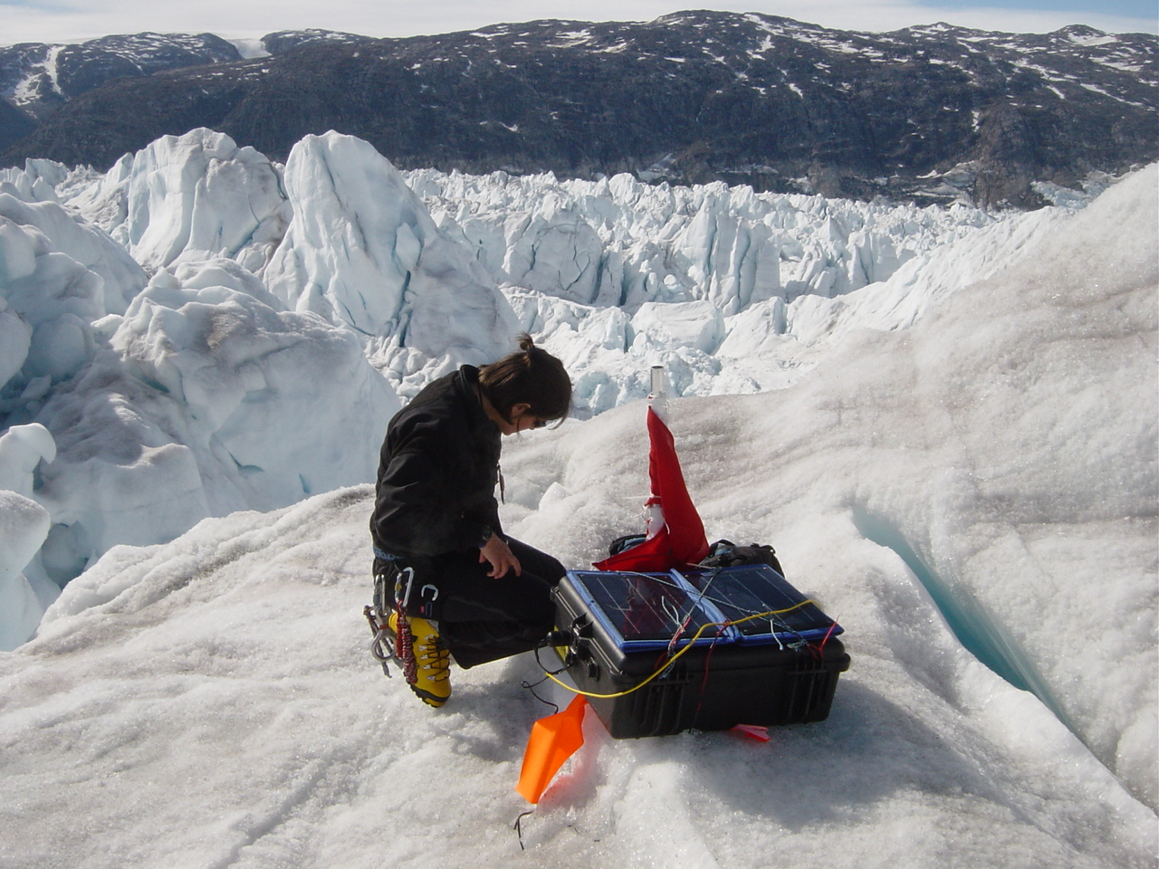
We set up six stations this afternoon, and were getting very efficient at it, averaging ~ 7 minutes at a site. Once we get to a site, we have to drill two 3-meter holes, to put our poles in, set up the GPS equipment and solar panels, and mark the site with lots of flags so that we can find it again. In this part of Helheim Glacier, we expect 1-1.5 meters of surface melt throughout the summer, which is why we have to drill our holes so deep. Shorter poles would just melt out in a matter of weeks.
June 30, 2006 Tasiilaq, Greenland
We installed 16 permanent GPS stations on the ice (see map), in addition to the two temporary stations that are near the calving front. We have three reference stations on nearby bedrock ridges, which is necessary in order to process the data and determine how fast the glacier is moving. Tomorrow we will pick up the snout (front) stations and head home.
TRIP 2: DATA DOWNLOAD and SITE FIXING! [Pedro Elosequi, Gordon Hamilton, Meredith Nettles, Leigh Stearns]
July 22, 2006 Tasiilaq, Greenland
Gordon and I arrived traveled straight from Orono to Boston, to Reykjavik, to Kulusuk, to Tasiilaq today (I suppose we started traveling yesterday)! We got to Tasiilaq at 10am and rested for a few hours before flying to the glacier at 2pm. Together with Meredith, we installed a tide gauge at an inlet near Helheim Glacier. We are interested in the relationship between tidal fluctuations and ice velocity � the ice velocity of many tidewater glaciers will vary 2-4% due to the tide. We also installed two GPS stations on the snout (front) of Helheim Glacier to measure this effect.
July 24, 2006
Unfortunately, many of our solar panels were not producing enough charge to run our GPS receivers, so we spent most of the day adjusting the panel setup to maximize the charge. This meant scavenging through the town dump, taking apart wood pallets, and building �solar panel frames�. The wind can be very strong (and the solar panels are very floppy) so we had to devise a way to keep the panels flat and open!
July 25, 2006
Pedro, Meredith, Gordon and I visited the each of the sites today. Depending on the state of the site, we redrilled holes, retied solar panels, swapped out receivers and downloaded data. We got to be pretty efficient at fixing the sites and it was always interesting to see what state they were in! At a few sites, crevasses had opened up BETWEEN our receiver and antenna. Luckily we found and fixed all the sites.
TRIP 3: SITE CLEAN-UP [Gordon Hamilton, Morten Langer, Meredith Nettles, Abbas Kahn, Leigh Stearns]
August 25, 2006 Tasiilaq, Greenland
I suppose this was supposed to be a site clean-up trip, but all we did today was install NEW stations. We got very interesting data from our first set up snout GPS stations, so today we set up four more � all within 3 km of the calving front. We also revisited one of the reference sites (on bedrock). It�s a good thing we have 3 reference sites, because the wind had ripped the solar panel completely off its backing.
The calving front had retreated a bit since our first trip. It seemed like there were even fewer decent landing spots for an enormous Bell 222 helicopter. There were more ice spires and fewer ice platforms. With much hunting, we managed to find four good sites though.
August 26, 2006 Tasiilaq, Greenland
Morten and Abbas arrived in the afternoon and we flew to Helheim shortly afterwards. We ended up retrieving 6 stations before the weather got too bad to fly in. They were particularly difficult sites to access, since the crevasses had grown since our previous visit. Crevasses divided our landing spot from our equipment at more than one site, and took a lot of time and energy to navigate. Fortunately we retrieved everything safely and efficiently!
The heliport had a BBQ when we got back from the field, and they were nice enough to invite us along. I got to try grilled whale, which was actually pretty tasty.
August 27, 2006 Tasiilaq, Greenland
We had an easy Sunday today because the pilot had the day off. So, we spent the day cleaning up gear, downloading the GPS receivers that we collected on Day 2, and planning for tomorrow.
August 28, 2006 Tasiilaq, Greenland Morten, Meredith, Gordon and I collected the rest of the sites today while Abbas worked with the reference GPS site (on the adjacent ridge). We were all very excited because we retrieved ALL of the units except 3 (and the snout stations). There was only one site that we couldn�t land at with the Bell 222 because the �crevasse-free� platform had become significantly smaller in the past month.
We saw the northern lights tonight. They were phenomenal but impossible to capture with a camera.
August 29, 2006 Tasiilaq, Greenland
Gordon and I retrieved the final GPS stations in the small and snazzy A-Star helicopter. It was much easier to land and work with. The only downfall was that its cabin was pretty small, but since we only had 4 sites to retrieve, it was ok. We got back to Tasiilaq at 12:30 and caught a 1pm ride to Kulusuk and are heading back home.
References
Ekström, G. et al. 2006. Seasonality and increasing frequency of Greenland glacial earthquakes, Science, 311.
Rignot, E. and P. Kanagaratnam. 2006. Changes in the velocity structure of the Greenland Ice Sheet, Science, 311.
Stearns, L.A. and G.S. Hamilton. 2005. Rapid changes of large tidewater glaciers in SE Greenland, AGU meeting. Zwally, H.J. et al. 2002. Surface melt induced acceleration of Greenland Ice Sheet flow. Science, 297.
pid changes of large tidewater glaciers in SE Greenland, AGU meeting. Zwally, H.J. et al. 2002. Surface melt induced acceleration of Greenland Ice Sheet flow. Science, 297.