
Project in Central Asia (2005-10)

CADIP Science Plan:
Field Activities
Summer 2005 reconnaissance
Summer-Fall 2006-2007 100-200m cores
Deep drilling 2007+
Ice Core Examinations:
| Cr-red | δD | 50μL |
| CO2-equilib. | δ18O | 0.5μL |
| IC | MS, Cl-, NO3-, SO42, Na+, NH4+, K+, Mg2+, Ca2+ | 4ml |
| ICP-MS | Sr, Cd, Cs, Ba, REE, Bi, U, As, Ti, Al, S, Ti, V, Cr, Ne, Fe, Co, Cu, Zn, Pb, Pb isotopes, Sc, Ag, Cd, Te, Sb | 4mL |
| Particle | size, distribution | |
| α-Spectroscopy | 210Pb | 100-200mL |
| AMS | 14C | 1kg |
| Thermal Combustion | OC/EC | 100mL |
| AFS | Hg | 10mL |
| AMS | 10Be/36Cl | 1kg |
| Microscopy | algae, bacteria, pollen | 1~20mL |
| DNA Sequence | algae, bacteria | 1~20mL |
| Stable Isotope | particulate organic, C, N | 1~20mL |
| Stratigraphy | ice layer, bubble density, grain size (thickness width) | 10*40mm |
| Meteorological | air temperature, air humidity wind speed, wind direction, atmospheric pressure, solar radiance characteristics, | |
| Glaciological | accumulation, ablation, evaporation, surface velocity, ice thickness, snow and firn stratigraphy |
A Collaborative Agreement for CADIP.
Based upon discussion undertaken during a meeting in Orono, Maine on 23-24 May 2005 representatives from the following countries intend to participate in ice coring activities in the Tien Shan, Kyrgyzstan and Pamir, Tajikistan as part of CADIP:
China
China Meteorological Administration (Qin Dahe)Cold and Arid Environmental Engineering Research Institute, Chinese Academy of Sciences (Shugui Hou, Ren Jiawen) Tibetan Plateau Institute (Yao Tandong, Shichang Kang)
France
Laboratoire de Glaciologie et Gèphysique de l'Environnement, Domaine Universitaire (Jerome Chappellaz)
Germany
Kommission fur Glaziologie der Bavarischen Academie der Wissenschaften, Munchen (Ludwig Braun, Christoph Mayer) Institute for Environmental Physics, University of Heidelberg (Dietmar Wagenbach)Institute of Environmental Geochemistry, University of Heidelberg (Michael Krachler, Bill Shotyk)
Japan
Research Institute of Humanity and Nature (Masyoshi Nakawo, Jumpei Kubota, Nozomu Takeuchi)Graduate School of Environmental Studies, Nagoya University (Koji Fujita)
Kyrgyzstan
Zenralasiatisches Institut für Angewandte Geowissenschaften in Bischkek (Wasili Michajljow)
Switzerland
Paul Scherrer Institut, Labor fur Radio- und Umweltchemie (Margit Schwikowski)ETH Institute for Particle Physics (Hans-Arno Synal)
Tajikistan
Institute of Water Problems, Hydroenergy and Ecology, Tajik Academy of Science (Alexander Finaev)Institute of Soils, Tajik Academy of Science (Peter Fetisov)
Russian Federation
Tomsk State University (Stanislaw Nikitin)
United States
University of Idaho (Vladimir Aizen, Elena Aizen, Daniel Joswiak, Arzhan Surazakov, John Marshall, Robert Brander)
Climate Change Institute, University of Maine (Paul Mayewski, Karl Kreutz, Andrei Kurbatov, Sharon Sneed, Michael Handley, Susan Kaspari, Bjorn Grigholm)
CADIP members agree to the following as part of our collaborative efforts:
- Data will be made accessible to all CADIP researchers with the understanding that the use of this data for presentation and publication will only be allowed with the permission of the institution that generated the data.
- Data will be released to the scientific community through international data centers immediately upon publication and no later than two years following final analyses.
- For purposes of developing an annually resolved depth/age scale all necessary data will be made available and published in a commonly constructed paper. CADIP researchers will agree to one common depth/age scale.
- All papers intended for publication by a CADIP researcher will be shared with representatives from other CADIP institutions in order to insure the highest possible collaboration and quality of science. Wherever possible papers will be co-authored by a combination of CADIP researchers from several institutions.
- A series of annual workshops will be held starting in 2006 for purposes of project planning and scientific exchange.
- CADIP researchers will conduct inter-calibrations between laboratories.
- CADIP institutions will be open to personnel exchange with other CADIP institutions.
- A reconnaissance field program in summer 2005 will be undertaken to develop data sufficient to demonstrate the viability of the Pamir site for recovery of a well- dated, well-preserved environmental record. This information will be made available to all CADIP institutions for incorporation in proposals seeking support for CADIP activities.
- A field program will be undertaken in 2006 or 2007 to recover one or more 150-300 m core(s) for use by CADIP researchers with logistic costs to be shared by CADIP institutions.
- A field program dedicated to the recovery of a core to bedrock following the 2006 (07) field program will be undertaken once funds are realized.
- Organization of this program including science and logistics will be undertaken as a joint effort by CADIP institutions. Vladimir Aizen will be the Chief Scientist for CADIP.
- CADIP is open to other institutions that can contribute to the scientific and logistic goals of CADIP.
Tien Shan and Pamir reconnaissance 2005
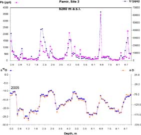
Figure 4. Snow/firn core isotope-geochemistry signal,
Fedchenko glacier (the site 1 core recovered at 5650 m
a.s.l. even better than this one).
Japanese / Russian / USA joint team have carried out first reconnaissance trip to Central Tien Shan (Kyrgyzstan) and Central Pamir (Tajikistan) in July-August 2005. The Grigorieva Ice-Cap in Central Tien Shan (4600 m a.s.l.) and Fedchenko Glacier snow/firn plateau (5280 -5650 m a.s.l.) have been investigated for potential ice-core drilling. A detailed radio-echo sounding survey conducted over 60 GPS-surveyed sites on the top of Grigorieva ice-cap where ice thickness reaches 110-120 m at the area selected for ice drilling. Two automatic weather stations have been assembled near the potential drilling sites on the Grigorieva ice-cap (4600) m, and on a Fedchenko Gl rock knob (5800 m) 150 m above the drilling site. These stations are recording the following parameters with hourly resolution: air temperature, humidity, wind speed, wind direction, atmospheric pressure, solar radiance duration, short and long wave radiation with hourly resolution. Two snow pits in each site have been dug out by the annual accumulation depth: 1m in the Grigorieva ice-cap and 2 m in the Fedchenko Gl. Three shallow ice cores (6, 9 and 12 m) were recovered at elevations: 4600 m a.s.l. (Grigorieva Gl.), 5280 m and 5650 m a.s.l. (Fedchenko Gl.). The surface topography of the Fedchenko Gl. snow/firn plateau (10x5 km) has been measured by GPS and coordinated to the benchmarks on the rock surface. Data of this survey will be used to develop the plateau high-resolution map, ice thickness, and ice flow velocity measurements. Twenty GPS coordinated wooden stakes 4 m high each established on the plateau. High-resolution stable isotope and chemical (ISPMS) data recovered from three shallow snow/firn cores and snow pits shows very clear preserved seasonal signal (Fig.4). The Pamir's ice core has better signal than Tien Shan ice core with a little more depleted amplitudes. The -8.2°C temperature has been recorded at 9 m of ice-hole at 5280 m Pamir�s drilling site. Snow/firn samples from the cores and snow pits will be also processed on microbiological analyses at the RIHN by Nozomu Takeuchi team. The Pamir drilling sites showed minimal snowmelt caused by solar radiation under air temperatures below 0°C. The radiation melt is negligible and form only thin ice crusts on the snow surface. We did not find a sign of water percolation in the Pamir cores. At the same time an effect of evaporation/sublimation from snow surface and at a depth of 0 -3 m is required special attention. Our collaborators in Kyrgyzstan and Tajikistan will collect the long-term meteorological and synoptic data necessary for ice-core data calibration and validation.